You are here: Home > Network List > AV - Alaska Volcano Observatory Stations List
> Station R17L Mt. Peulik Volcano, AVO PLK4, AK, USA > Earthquake Result Viewer
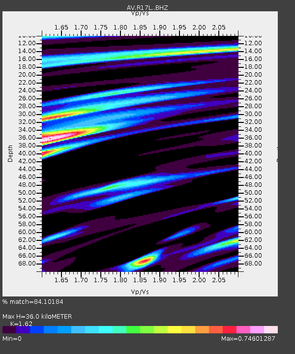
R17L Mt. Peulik Volcano, AVO PLK4, AK, USA - Earthquake Result Viewer
| Earthquake location: |
Southeast Of Loyalty Islands |
| Earthquake latitude/longitude: |
-22.1/170.9 |
| Earthquake time(UTC): |
2022/08/14 (226) 21:04:46 GMT |
| Earthquake Depth: |
83 km |
| Earthquake Magnitude: |
6.2 mww |
| Earthquake Catalog/Contributor: |
NEIC PDE/us |
|
| Network: |
AV Alaska Volcano Observatory |
| Station: |
R17L Mt. Peulik Volcano, AVO PLK4, AK, USA |
| Lat/Lon: |
57.63 N/156.36 W |
| Elevation: |
524 m |
|
| Distance: |
84.0 deg |
| Az: |
16.997 deg |
| Baz: |
210.272 deg |
| Ray Param: |
0.045643687 |
| Estimated Moho Depth: |
36.0 km |
| Estimated Crust Vp/Vs: |
1.62 |
| Assumed Crust Vp: |
6.1 km/s |
| Estimated Crust Vs: |
3.765 km/s |
| Estimated Crust Poisson's Ratio: |
0.19 |
|
| Radial Match: |
84.10184 % |
| Radial Bump: |
400 |
| Transverse Match: |
72.16478 % |
| Transverse Bump: |
400 |
| SOD ConfigId: |
28764291 |
| Insert Time: |
2022-08-28 21:13:09.425 +0000 |
| GWidth: |
2.5 |
| Max Bumps: |
400 |
| Tol: |
0.001 |
|

Signal To Noise
| Channel | StoN | STA | LTA |
| AV:R17L: :BHZ:20220814T21:16:36.475014Z | 14.634798 | 1.1737476E-6 | 8.020251E-8 |
| AV:R17L: :BHN:20220814T21:16:36.475014Z | 2.1062748 | 2.3093021E-7 | 1.0963916E-7 |
| AV:R17L: :BHE:20220814T21:16:36.475014Z | 1.4912455 | 1.4859695E-7 | 9.964621E-8 |
| Arrivals |
| Ps | 3.8 SECOND |
| PpPs | 15 SECOND |
| PsPs/PpSs | 19 SECOND |


