You are here: Home > Network List > CI - Caltech Regional Seismic Network Stations List
> Station LRL Laurel Mtn Radio Fac, Ridgecrest, CA, USA > Earthquake Result Viewer
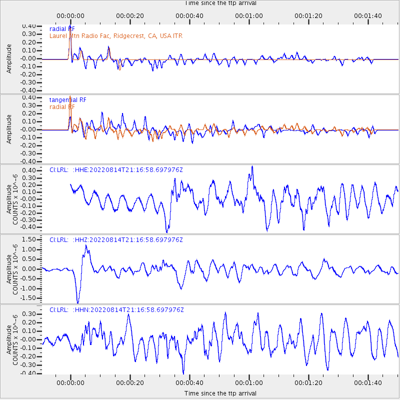
LRL Laurel Mtn Radio Fac, Ridgecrest, CA, USA - Earthquake Result Viewer
*The percent match for this event was below the threshold and hence no stack was calculated.
| Earthquake location: |
Southeast Of Loyalty Islands |
| Earthquake latitude/longitude: |
-22.1/170.9 |
| Earthquake time(UTC): |
2022/08/14 (226) 21:04:46 GMT |
| Earthquake Depth: |
83 km |
| Earthquake Magnitude: |
6.2 mww |
| Earthquake Catalog/Contributor: |
NEIC PDE/us |
|
| Network: |
CI Caltech Regional Seismic Network |
| Station: |
LRL Laurel Mtn Radio Fac, Ridgecrest, CA, USA |
| Lat/Lon: |
35.48 N/117.68 W |
| Elevation: |
1340 m |
|
| Distance: |
88.5 deg |
| Az: |
50.691 deg |
| Baz: |
241.574 deg |
| Ray Param: |
$rayparam |
*The percent match for this event was below the threshold and hence was not used in the summary stack. |
|
| Radial Match: |
78.28614 % |
| Radial Bump: |
400 |
| Transverse Match: |
66.395905 % |
| Transverse Bump: |
400 |
| SOD ConfigId: |
28764291 |
| Insert Time: |
2022-08-28 21:18:03.776 +0000 |
| GWidth: |
2.5 |
| Max Bumps: |
400 |
| Tol: |
0.001 |
|
Signal To Noise
| Channel | StoN | STA | LTA |
| CI:LRL: :HHZ:20220814T21:16:58.697976Z | 13.643757 | 8.076151E-7 | 5.9193017E-8 |
| CI:LRL: :HHN:20220814T21:16:58.697976Z | 0.74285346 | 7.225512E-8 | 9.7267E-8 |
| CI:LRL: :HHE:20220814T21:16:58.697976Z | 2.3718178 | 2.4128184E-7 | 1.0172866E-7 |
| Arrivals |
| Ps | |
| PpPs | |
| PsPs/PpSs | |


