You are here: Home > Network List > AU - Australian Seismological Centre Stations List
> Station PSAA2 Pilbara Seismic Array Element A2 > Earthquake Result Viewer
PSAA2 Pilbara Seismic Array Element A2 - Earthquake Result Viewer
| Earthquake location: |
Mariana Islands Region |
| Earthquake latitude/longitude: |
16.8/147.1 |
| Earthquake time(UTC): |
2018/08/28 (240) 22:35:14 GMT |
| Earthquake Depth: |
53 km |
| Earthquake Magnitude: |
6.6 Mi |
| Earthquake Catalog/Contributor: |
NEIC PDE/at |
|
| Network: |
AU Australian Seismological Centre |
| Station: |
PSAA2 Pilbara Seismic Array Element A2 |
| Lat/Lon: |
21.56 S/119.85 E |
| Elevation: |
330 m |
|
| Distance: |
46.6 deg |
| Az: |
215.953 deg |
| Baz: |
37.168 deg |
| Ray Param: |
0.0704303 |
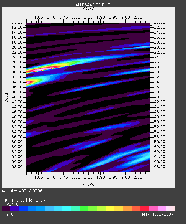
| Estimated Moho Depth: |
34.0 km |
| Estimated Crust Vp/Vs: |
1.60 |
| Assumed Crust Vp: |
6.464 km/s |
| Estimated Crust Vs: |
4.04 km/s |
| Estimated Crust Poisson's Ratio: |
0.18 |
|
| Radial Match: |
89.619736 % |
| Radial Bump: |
392 |
| Transverse Match: |
68.05229 % |
| Transverse Bump: |
400 |
| SOD ConfigId: |
2825771 |
| Insert Time: |
2018-09-11 22:49:23.175 +0000 |
| GWidth: |
2.5 |
| Max Bumps: |
400 |
| Tol: |
0.001 |
|

Signal To Noise
| Channel | StoN | STA | LTA |
| AU:PSAA2:00:BHZ:20180828T22:43:05.919006Z | 8.872379 | 3.978519E-6 | 4.4841627E-7 |
| AU:PSAA2:00:BH1:20180828T22:43:05.919006Z | 3.0566938 | 1.0884648E-6 | 3.560922E-7 |
| AU:PSAA2:00:BH2:20180828T22:43:05.919006Z | 5.2313333 | 1.5618095E-6 | 2.9854903E-7 |
| Arrivals |
| Ps | 3.4 SECOND |
| PpPs | 13 SECOND |
| PsPs/PpSs | 16 SECOND |


