You are here: Home > Network List > IU - Global Seismograph Network (GSN - IRIS/USGS) Stations List
> Station JOHN Johnston Island, USA > Earthquake Result Viewer
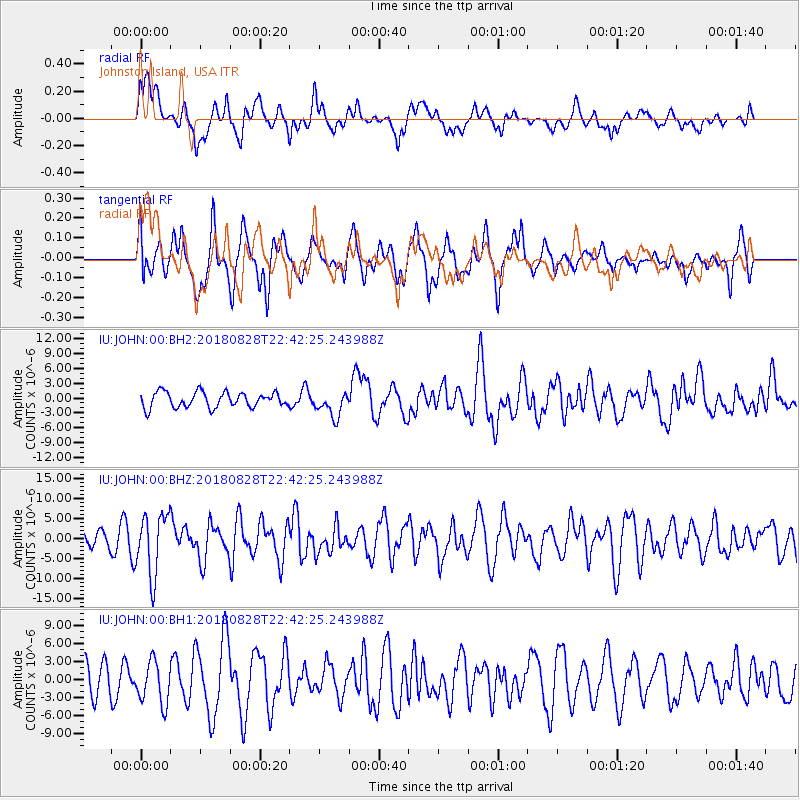
JOHN Johnston Island, USA - Earthquake Result Viewer
*The percent match for this event was below the threshold and hence no stack was calculated.
| Earthquake location: |
Mariana Islands Region |
| Earthquake latitude/longitude: |
16.8/147.1 |
| Earthquake time(UTC): |
2018/08/28 (240) 22:35:14 GMT |
| Earthquake Depth: |
53 km |
| Earthquake Magnitude: |
6.6 Mi |
| Earthquake Catalog/Contributor: |
NEIC PDE/at |
|
| Network: |
IU Global Seismograph Network (GSN - IRIS/USGS) |
| Station: |
JOHN Johnston Island, USA |
| Lat/Lon: |
16.73 N/169.53 W |
| Elevation: |
2.0 m |
|
| Distance: |
41.5 deg |
| Az: |
83.584 deg |
| Baz: |
276.592 deg |
| Ray Param: |
$rayparam |
*The percent match for this event was below the threshold and hence was not used in the summary stack. |
|
| Radial Match: |
59.8818 % |
| Radial Bump: |
400 |
| Transverse Match: |
52.87103 % |
| Transverse Bump: |
400 |
| SOD ConfigId: |
2825771 |
| Insert Time: |
2018-09-11 22:51:33.750 +0000 |
| GWidth: |
2.5 |
| Max Bumps: |
400 |
| Tol: |
0.001 |
|
Signal To Noise
| Channel | StoN | STA | LTA |
| IU:JOHN:00:BHZ:20180828T22:42:25.243988Z | 3.785791 | 7.664171E-6 | 2.024457E-6 |
| IU:JOHN:00:BH1:20180828T22:42:25.243988Z | 1.0532378 | 3.5493088E-6 | 3.3699027E-6 |
| IU:JOHN:00:BH2:20180828T22:42:25.243988Z | 1.634386 | 2.5264605E-6 | 1.5458164E-6 |
| Arrivals |
| Ps | |
| PpPs | |
| PsPs/PpSs | |


