You are here: Home > Network List > IW - Intermountain West Stations List
> Station MOOW Moose Ponds, Wyoming, USA > Earthquake Result Viewer
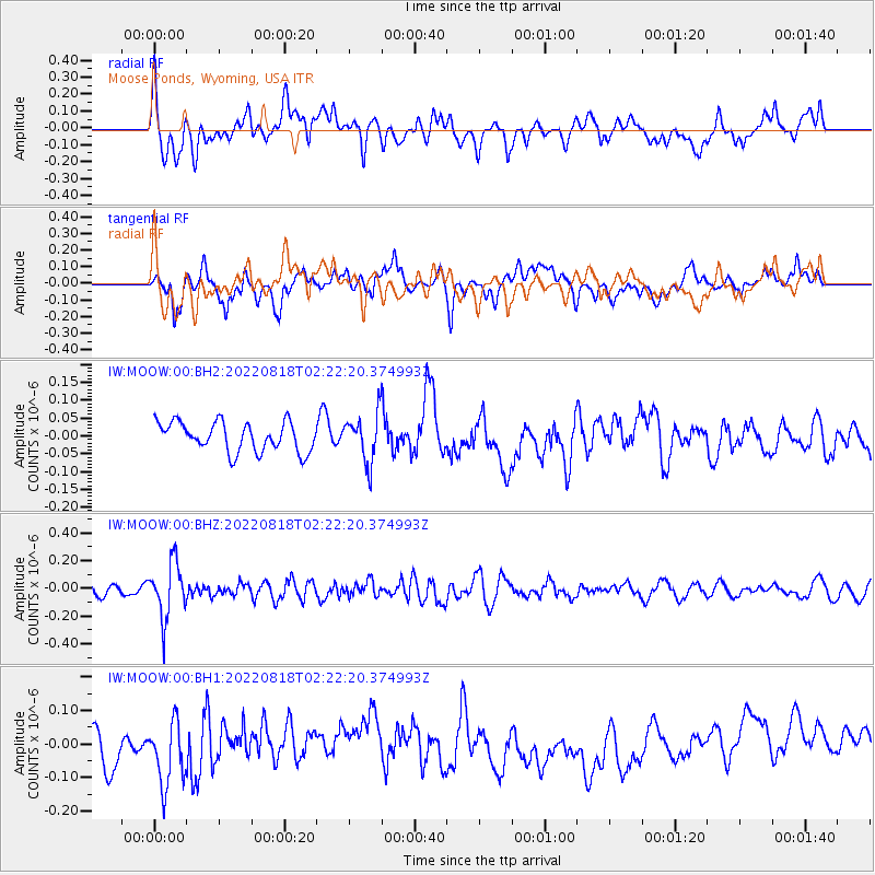
MOOW Moose Ponds, Wyoming, USA - Earthquake Result Viewer
*The percent match for this event was below the threshold and hence no stack was calculated.
| Earthquake location: |
Chile-Argentina Border Region |
| Earthquake latitude/longitude: |
-34.3/-70.6 |
| Earthquake time(UTC): |
2022/08/18 (230) 02:10:23 GMT |
| Earthquake Depth: |
104 km |
| Earthquake Magnitude: |
5.3 Mwr |
| Earthquake Catalog/Contributor: |
NEIC PDE/us |
|
| Network: |
IW Intermountain West |
| Station: |
MOOW Moose Ponds, Wyoming, USA |
| Lat/Lon: |
43.75 N/110.74 W |
| Elevation: |
2128 m |
|
| Distance: |
85.9 deg |
| Az: |
332.055 deg |
| Baz: |
147.655 deg |
| Ray Param: |
$rayparam |
*The percent match for this event was below the threshold and hence was not used in the summary stack. |
|
| Radial Match: |
52.11118 % |
| Radial Bump: |
400 |
| Transverse Match: |
53.338783 % |
| Transverse Bump: |
400 |
| SOD ConfigId: |
28764291 |
| Insert Time: |
2022-09-01 02:20:29.752 +0000 |
| GWidth: |
2.5 |
| Max Bumps: |
400 |
| Tol: |
0.001 |
|
Signal To Noise
| Channel | StoN | STA | LTA |
| IW:MOOW:00:BHZ:20220818T02:22:20.374993Z | 5.555992 | 1.9800392E-7 | 3.5637907E-8 |
| IW:MOOW:00:BH1:20220818T02:22:20.374993Z | 2.0247684 | 1.0224114E-7 | 5.0495224E-8 |
| IW:MOOW:00:BH2:20220818T02:22:20.374993Z | 1.6581012 | 6.791926E-8 | 4.096207E-8 |
| Arrivals |
| Ps | |
| PpPs | |
| PsPs/PpSs | |


