You are here: Home > Network List > IU - Global Seismograph Network (GSN - IRIS/USGS) Stations List
> Station POHA Pohakuloa, Hawaii, USA > Earthquake Result Viewer
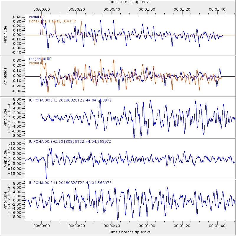
POHA Pohakuloa, Hawaii, USA - Earthquake Result Viewer
*The percent match for this event was below the threshold and hence no stack was calculated.
| Earthquake location: |
Mariana Islands Region |
| Earthquake latitude/longitude: |
16.8/147.1 |
| Earthquake time(UTC): |
2018/08/28 (240) 22:35:14 GMT |
| Earthquake Depth: |
53 km |
| Earthquake Magnitude: |
6.6 Mi |
| Earthquake Catalog/Contributor: |
NEIC PDE/at |
|
| Network: |
IU Global Seismograph Network (GSN - IRIS/USGS) |
| Station: |
POHA Pohakuloa, Hawaii, USA |
| Lat/Lon: |
19.76 N/155.53 W |
| Elevation: |
1990 m |
|
| Distance: |
54.3 deg |
| Az: |
77.491 deg |
| Baz: |
276.856 deg |
| Ray Param: |
$rayparam |
*The percent match for this event was below the threshold and hence was not used in the summary stack. |
|
| Radial Match: |
67.39372 % |
| Radial Bump: |
400 |
| Transverse Match: |
49.9448 % |
| Transverse Bump: |
374 |
| SOD ConfigId: |
2825771 |
| Insert Time: |
2018-09-11 22:51:47.599 +0000 |
| GWidth: |
2.5 |
| Max Bumps: |
400 |
| Tol: |
0.001 |
|
Signal To Noise
| Channel | StoN | STA | LTA |
| IU:POHA:00:BHZ:20180828T22:44:04.56897Z | 3.131672 | 7.0252463E-6 | 2.2432894E-6 |
| IU:POHA:00:BH1:20180828T22:44:04.56897Z | 0.9050383 | 2.072528E-6 | 2.2899894E-6 |
| IU:POHA:00:BH2:20180828T22:44:04.56897Z | 3.7265966 | 3.6457702E-6 | 9.783109E-7 |
| Arrivals |
| Ps | |
| PpPs | |
| PsPs/PpSs | |


