You are here: Home > Network List > NO - Norwegian Seismic Array Network Stations List
> Station SPB5 > Earthquake Result Viewer
SPB5 - Earthquake Result Viewer
| Earthquake location: |
Mariana Islands Region |
| Earthquake latitude/longitude: |
16.8/147.1 |
| Earthquake time(UTC): |
2018/08/28 (240) 22:35:14 GMT |
| Earthquake Depth: |
53 km |
| Earthquake Magnitude: |
6.6 Mi |
| Earthquake Catalog/Contributor: |
NEIC PDE/at |
|
| Network: |
NO Norwegian Seismic Array Network |
| Station: |
SPB5 |
| Lat/Lon: |
78.18 N/16.37 E |
| Elevation: |
295 m |
|
| Distance: |
81.2 deg |
| Az: |
350.907 deg |
| Baz: |
47.256 deg |
| Ray Param: |
0.04762704 |
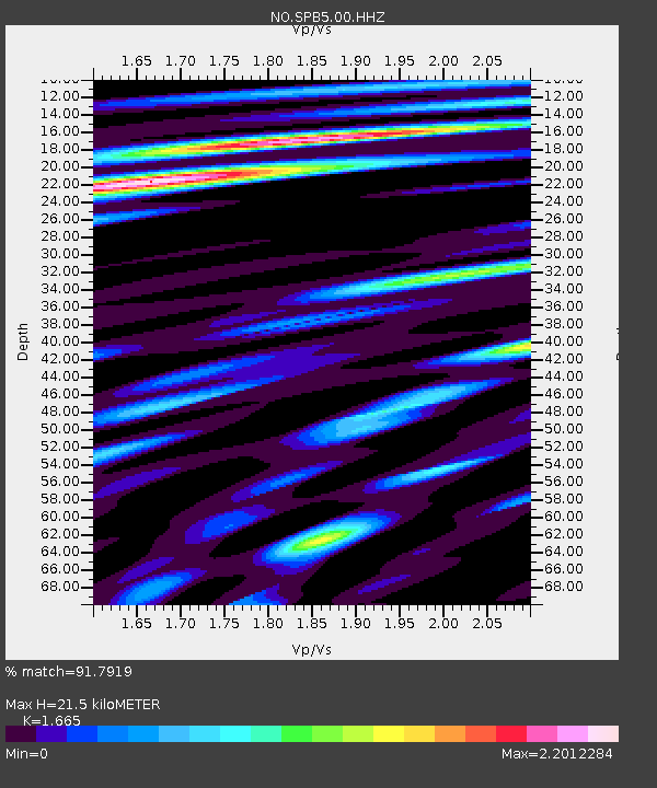
| Estimated Moho Depth: |
21.5 km |
| Estimated Crust Vp/Vs: |
1.66 |
| Assumed Crust Vp: |
6.545 km/s |
| Estimated Crust Vs: |
3.931 km/s |
| Estimated Crust Poisson's Ratio: |
0.22 |
|
| Radial Match: |
91.7919 % |
| Radial Bump: |
400 |
| Transverse Match: |
88.38735 % |
| Transverse Bump: |
400 |
| SOD ConfigId: |
2825771 |
| Insert Time: |
2018-09-11 22:53:13.538 +0000 |
| GWidth: |
2.5 |
| Max Bumps: |
400 |
| Tol: |
0.001 |
|

Signal To Noise
| Channel | StoN | STA | LTA |
| NO:SPB5:00:HHZ:20180828T22:46:53.262024Z | 11.444988 | 1.2455351E-6 | 1.08828E-7 |
| NO:SPB5:00:HHN:20180828T22:46:53.262024Z | 3.509865 | 3.8673454E-7 | 1.1018501E-7 |
| NO:SPB5:00:HHE:20180828T22:46:53.262024Z | 4.745608 | 5.4405524E-7 | 1.1464395E-7 |
| Arrivals |
| Ps | 2.3 SECOND |
| PpPs | 8.5 SECOND |
| PsPs/PpSs | 11 SECOND |


