You are here: Home > Network List > AV - Alaska Volcano Observatory Stations List
> Station MAPS Pakushin Southeast, Makushin Volcano, Alaska > Earthquake Result Viewer
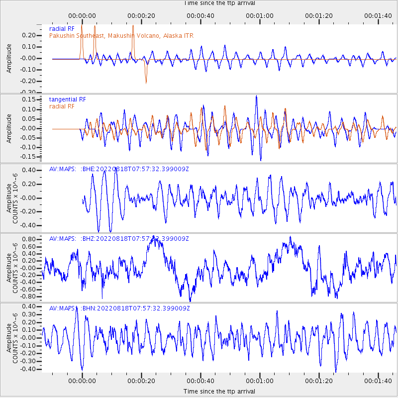
MAPS Pakushin Southeast, Makushin Volcano, Alaska - Earthquake Result Viewer
*The percent match for this event was below the threshold and hence no stack was calculated.
| Earthquake location: |
Minahassa Peninsula, Sulawesi |
| Earthquake latitude/longitude: |
0.3/124.4 |
| Earthquake time(UTC): |
2022/08/18 (230) 07:46:27 GMT |
| Earthquake Depth: |
167 km |
| Earthquake Magnitude: |
5.4 mww |
| Earthquake Catalog/Contributor: |
NEIC PDE/us |
|
| Network: |
AV Alaska Volcano Observatory |
| Station: |
MAPS Pakushin Southeast, Makushin Volcano, Alaska |
| Lat/Lon: |
53.81 N/166.94 W |
| Elevation: |
333 m |
|
| Distance: |
77.3 deg |
| Az: |
34.501 deg |
| Baz: |
252.755 deg |
| Ray Param: |
$rayparam |
*The percent match for this event was below the threshold and hence was not used in the summary stack. |
|
| Radial Match: |
37.101254 % |
| Radial Bump: |
400 |
| Transverse Match: |
41.94825 % |
| Transverse Bump: |
400 |
| SOD ConfigId: |
28764291 |
| Insert Time: |
2022-09-01 07:52:16.406 +0000 |
| GWidth: |
2.5 |
| Max Bumps: |
400 |
| Tol: |
0.001 |
|
Signal To Noise
| Channel | StoN | STA | LTA |
| AV:MAPS: :BHZ:20220818T07:57:32.399009Z | 1.377014 | 2.7915542E-7 | 2.0272518E-7 |
| AV:MAPS: :BHN:20220818T07:57:32.399009Z | 2.0476022 | 2.1666361E-7 | 1.0581332E-7 |
| AV:MAPS: :BHE:20220818T07:57:32.399009Z | 0.51273876 | 1.04850194E-7 | 2.0449049E-7 |
| Arrivals |
| Ps | |
| PpPs | |
| PsPs/PpSs | |


