You are here: Home > Network List > TX - Texas Seismological Network Stations List
> Station PB03 Z > Earthquake Result Viewer
PB03 Z - Earthquake Result Viewer
| Earthquake location: |
Mariana Islands Region |
| Earthquake latitude/longitude: |
16.8/147.1 |
| Earthquake time(UTC): |
2018/08/28 (240) 22:35:14 GMT |
| Earthquake Depth: |
53 km |
| Earthquake Magnitude: |
6.6 Mi |
| Earthquake Catalog/Contributor: |
NEIC PDE/at |
|
| Network: |
TX Texas Seismological Network |
| Station: |
PB03 Z |
| Lat/Lon: |
31.08 N/103.51 W |
| Elevation: |
817 m |
|
| Distance: |
97.2 deg |
| Az: |
54.658 deg |
| Baz: |
294.396 deg |
| Ray Param: |
0.04025378 |
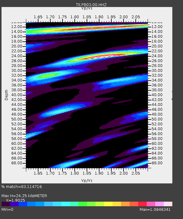
| Estimated Moho Depth: |
24.25 km |
| Estimated Crust Vp/Vs: |
1.90 |
| Assumed Crust Vp: |
6.121 km/s |
| Estimated Crust Vs: |
3.217 km/s |
| Estimated Crust Poisson's Ratio: |
0.31 |
|
| Radial Match: |
83.114716 % |
| Radial Bump: |
400 |
| Transverse Match: |
74.28036 % |
| Transverse Bump: |
400 |
| SOD ConfigId: |
2825771 |
| Insert Time: |
2018-09-11 22:54:48.570 +0000 |
| GWidth: |
2.5 |
| Max Bumps: |
400 |
| Tol: |
0.001 |
|

Signal To Noise
| Channel | StoN | STA | LTA |
| TX:PB03:00:HHZ:20180828T22:48:09.359985Z | 4.3195777 | 4.490728E-7 | 1.039622E-7 |
| TX:PB03:00:HH1:20180828T22:48:09.359985Z | 1.1961238 | 9.840406E-8 | 8.2269125E-8 |
| TX:PB03:00:HH2:20180828T22:48:09.359985Z | 1.639909 | 9.3444385E-8 | 5.6981442E-8 |
| Arrivals |
| Ps | 3.6 SECOND |
| PpPs | 11 SECOND |
| PsPs/PpSs | 15 SECOND |


