You are here: Home > Network List > US - United States National Seismic Network Stations List
> Station MSO Missoula, Montana, USA > Earthquake Result Viewer
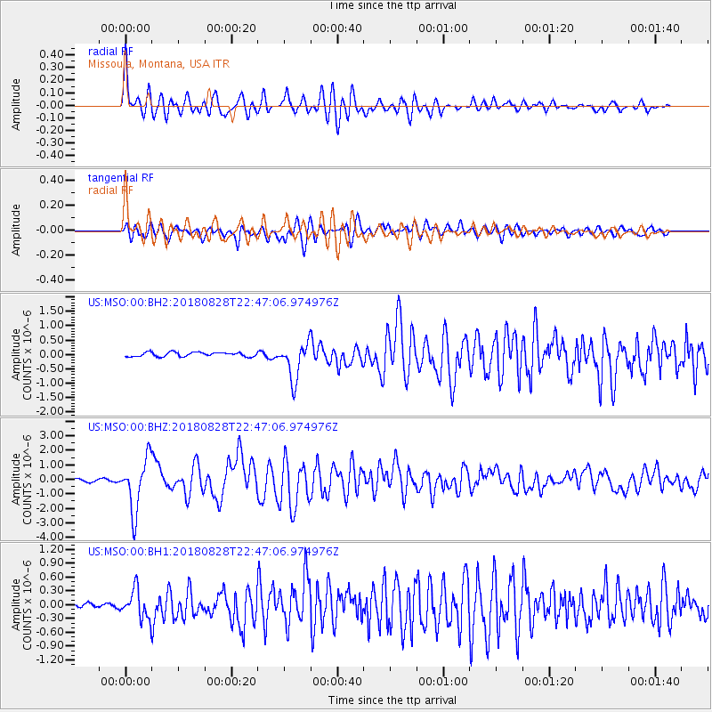
MSO Missoula, Montana, USA - Earthquake Result Viewer
*The percent match for this event was below the threshold and hence no stack was calculated.
| Earthquake location: |
Mariana Islands Region |
| Earthquake latitude/longitude: |
16.8/147.1 |
| Earthquake time(UTC): |
2018/08/28 (240) 22:35:14 GMT |
| Earthquake Depth: |
53 km |
| Earthquake Magnitude: |
6.6 Mi |
| Earthquake Catalog/Contributor: |
NEIC PDE/at |
|
| Network: |
US United States National Seismic Network |
| Station: |
MSO Missoula, Montana, USA |
| Lat/Lon: |
46.83 N/113.94 W |
| Elevation: |
1264 m |
|
| Distance: |
83.9 deg |
| Az: |
43.009 deg |
| Baz: |
287.905 deg |
| Ray Param: |
$rayparam |
*The percent match for this event was below the threshold and hence was not used in the summary stack. |
|
| Radial Match: |
75.96808 % |
| Radial Bump: |
400 |
| Transverse Match: |
78.21979 % |
| Transverse Bump: |
400 |
| SOD ConfigId: |
2825771 |
| Insert Time: |
2018-09-11 22:55:40.447 +0000 |
| GWidth: |
2.5 |
| Max Bumps: |
400 |
| Tol: |
0.001 |
|
Signal To Noise
| Channel | StoN | STA | LTA |
| US:MSO:00:BHZ:20180828T22:47:06.974976Z | 22.14247 | 1.8273741E-6 | 8.2528025E-8 |
| US:MSO:00:BH1:20180828T22:47:06.974976Z | 3.4333053 | 3.1448096E-7 | 9.1597144E-8 |
| US:MSO:00:BH2:20180828T22:47:06.974976Z | 8.918445 | 6.5577376E-7 | 7.353005E-8 |
| Arrivals |
| Ps | |
| PpPs | |
| PsPs/PpSs | |


