You are here: Home > Network List > N4 - Central and EAstern US Network Stations List
> Station Y52A Lilburn, GA, USA > Earthquake Result Viewer
Y52A Lilburn, GA, USA - Earthquake Result Viewer
| Earthquake location: |
Near Coast Of Ecuador |
| Earthquake latitude/longitude: |
-0.2/-80.7 |
| Earthquake time(UTC): |
2022/08/21 (233) 10:28:00 GMT |
| Earthquake Depth: |
10 km |
| Earthquake Magnitude: |
5.5 mww |
| Earthquake Catalog/Contributor: |
NEIC PDE/us |
|
| Network: |
N4 Central and EAstern US Network |
| Station: |
Y52A Lilburn, GA, USA |
| Lat/Lon: |
33.86 N/84.06 W |
| Elevation: |
286 m |
|
| Distance: |
34.1 deg |
| Az: |
355.005 deg |
| Baz: |
173.993 deg |
| Ray Param: |
0.077927046 |
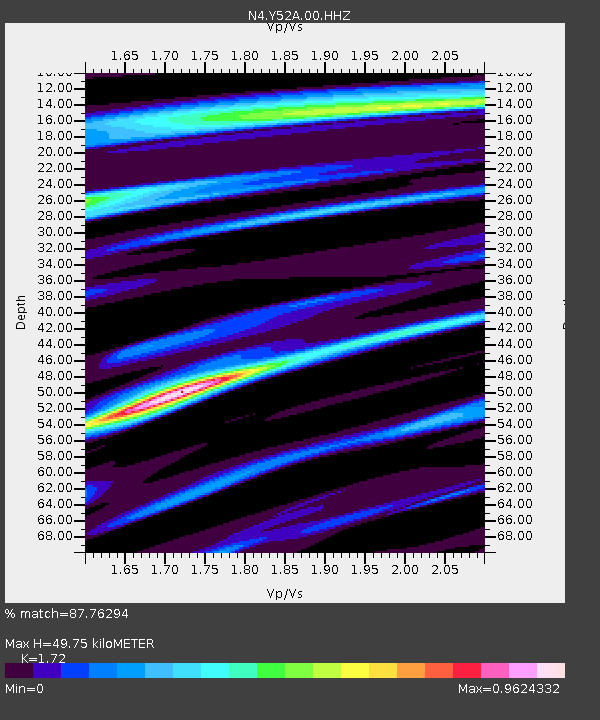
| Estimated Moho Depth: |
49.75 km |
| Estimated Crust Vp/Vs: |
1.72 |
| Assumed Crust Vp: |
6.719 km/s |
| Estimated Crust Vs: |
3.907 km/s |
| Estimated Crust Poisson's Ratio: |
0.24 |
|
| Radial Match: |
87.76294 % |
| Radial Bump: |
317 |
| Transverse Match: |
71.98807 % |
| Transverse Bump: |
400 |
| SOD ConfigId: |
28764291 |
| Insert Time: |
2022-09-04 10:47:53.401 +0000 |
| GWidth: |
2.5 |
| Max Bumps: |
400 |
| Tol: |
0.001 |
|

Signal To Noise
| Channel | StoN | STA | LTA |
| N4:Y52A:00:HHZ:20220821T10:34:14.250015Z | 5.8356986 | 2.940386E-7 | 5.038619E-8 |
| N4:Y52A:00:HH1:20220821T10:34:14.250015Z | 3.356553 | 1.6309039E-7 | 4.8588653E-8 |
| N4:Y52A:00:HH2:20220821T10:34:14.250015Z | 1.4238381 | 4.9548028E-8 | 3.479892E-8 |
| Arrivals |
| Ps | 5.8 SECOND |
| PpPs | 18 SECOND |
| PsPs/PpSs | 24 SECOND |


