You are here: Home > Network List > N4 - Central and EAstern US Network Stations List
> Station Y49A Blount Mountain, AL, USA > Earthquake Result Viewer
Y49A Blount Mountain, AL, USA - Earthquake Result Viewer
| Earthquake location: |
Near Coast Of Ecuador |
| Earthquake latitude/longitude: |
-0.2/-80.7 |
| Earthquake time(UTC): |
2022/08/21 (233) 10:28:00 GMT |
| Earthquake Depth: |
10 km |
| Earthquake Magnitude: |
5.5 mww |
| Earthquake Catalog/Contributor: |
NEIC PDE/us |
|
| Network: |
N4 Central and EAstern US Network |
| Station: |
Y49A Blount Mountain, AL, USA |
| Lat/Lon: |
33.86 N/86.41 W |
| Elevation: |
362 m |
|
| Distance: |
34.3 deg |
| Az: |
351.56 deg |
| Baz: |
169.841 deg |
| Ray Param: |
0.07779348 |
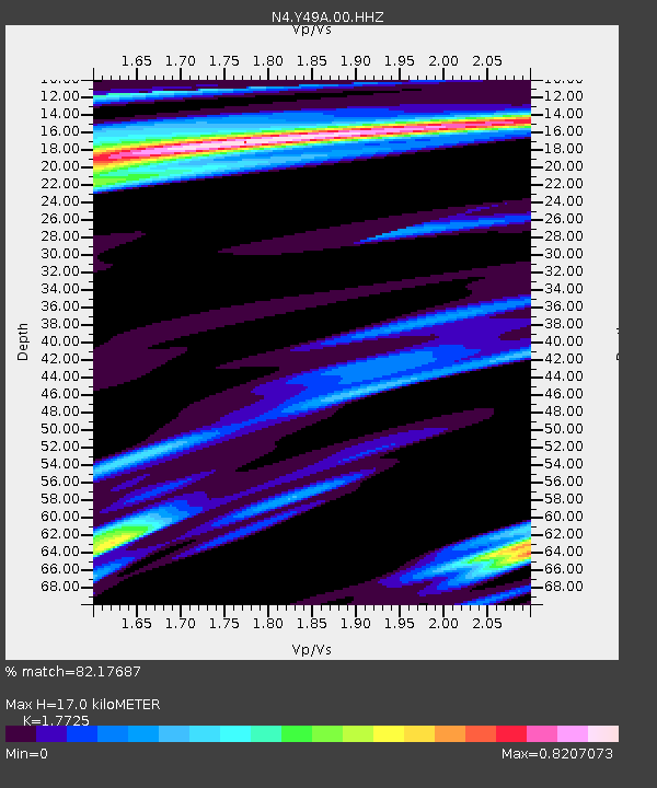
| Estimated Moho Depth: |
17.0 km |
| Estimated Crust Vp/Vs: |
1.77 |
| Assumed Crust Vp: |
6.565 km/s |
| Estimated Crust Vs: |
3.704 km/s |
| Estimated Crust Poisson's Ratio: |
0.27 |
|
| Radial Match: |
82.17687 % |
| Radial Bump: |
400 |
| Transverse Match: |
55.169674 % |
| Transverse Bump: |
400 |
| SOD ConfigId: |
28764291 |
| Insert Time: |
2022-09-04 10:47:53.795 +0000 |
| GWidth: |
2.5 |
| Max Bumps: |
400 |
| Tol: |
0.001 |
|

Signal To Noise
| Channel | StoN | STA | LTA |
| N4:Y49A:00:HHZ:20220821T10:34:16.580002Z | 4.750056 | 2.5686737E-7 | 5.4076708E-8 |
| N4:Y49A:00:HH1:20220821T10:34:16.580002Z | 2.287458 | 1.07880126E-7 | 4.716158E-8 |
| N4:Y49A:00:HH2:20220821T10:34:16.580002Z | 1.0342557 | 5.5820415E-8 | 5.3971576E-8 |
| Arrivals |
| Ps | 2.2 SECOND |
| PpPs | 6.6 SECOND |
| PsPs/PpSs | 8.8 SECOND |


