You are here: Home > Network List > N4 - Central and EAstern US Network Stations List
> Station Y60A Bolivia, NC, USA > Earthquake Result Viewer
Y60A Bolivia, NC, USA - Earthquake Result Viewer
| Earthquake location: |
Near Coast Of Ecuador |
| Earthquake latitude/longitude: |
-0.2/-80.7 |
| Earthquake time(UTC): |
2022/08/21 (233) 10:28:00 GMT |
| Earthquake Depth: |
10 km |
| Earthquake Magnitude: |
5.5 mww |
| Earthquake Catalog/Contributor: |
NEIC PDE/us |
|
| Network: |
N4 Central and EAstern US Network |
| Station: |
Y60A Bolivia, NC, USA |
| Lat/Lon: |
34.00 N/78.22 W |
| Elevation: |
7.0 m |
|
| Distance: |
34.1 deg |
| Az: |
3.68 deg |
| Baz: |
184.431 deg |
| Ray Param: |
0.07789092 |
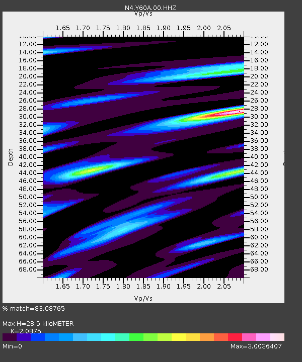
| Estimated Moho Depth: |
28.5 km |
| Estimated Crust Vp/Vs: |
2.09 |
| Assumed Crust Vp: |
6.565 km/s |
| Estimated Crust Vs: |
3.145 km/s |
| Estimated Crust Poisson's Ratio: |
0.35 |
|
| Radial Match: |
83.08765 % |
| Radial Bump: |
400 |
| Transverse Match: |
45.12823 % |
| Transverse Bump: |
400 |
| SOD ConfigId: |
28764291 |
| Insert Time: |
2022-09-04 10:47:56.614 +0000 |
| GWidth: |
2.5 |
| Max Bumps: |
400 |
| Tol: |
0.001 |
|

Signal To Noise
| Channel | StoN | STA | LTA |
| N4:Y60A:00:HHZ:20220821T10:34:14.888992Z | 3.8916042 | 3.6691742E-7 | 9.428436E-8 |
| N4:Y60A:00:HH1:20220821T10:34:14.888992Z | 2.5042312 | 3.6656516E-7 | 1.4637833E-7 |
| N4:Y60A:00:HH2:20220821T10:34:14.888992Z | 1.0155339 | 2.2474134E-7 | 2.2130362E-7 |
| Arrivals |
| Ps | 5.1 SECOND |
| PpPs | 13 SECOND |
| PsPs/PpSs | 18 SECOND |


