You are here: Home > Network List > NM - Cooperative New Madrid Seismic Network Stations List
> Station HDAR2 I40 Weigh Station,West Memphis,AR > Earthquake Result Viewer
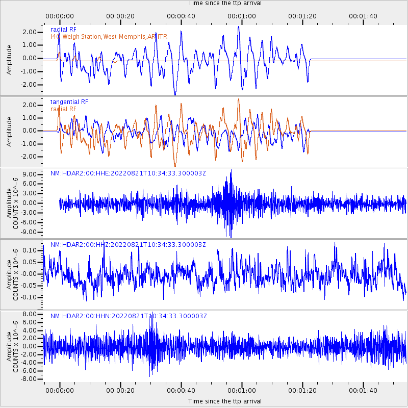
HDAR2 I40 Weigh Station,West Memphis,AR - Earthquake Result Viewer
*The percent match for this event was below the threshold and hence no stack was calculated.
| Earthquake location: |
Near Coast Of Ecuador |
| Earthquake latitude/longitude: |
-0.2/-80.7 |
| Earthquake time(UTC): |
2022/08/21 (233) 10:28:00 GMT |
| Earthquake Depth: |
10 km |
| Earthquake Magnitude: |
5.5 mww |
| Earthquake Catalog/Contributor: |
NEIC PDE/us |
|
| Network: |
NM Cooperative New Madrid Seismic Network |
| Station: |
HDAR2 I40 Weigh Station,West Memphis,AR |
| Lat/Lon: |
35.15 N/90.09 W |
| Elevation: |
100 m |
|
| Distance: |
36.3 deg |
| Az: |
346.946 deg |
| Baz: |
163.999 deg |
| Ray Param: |
$rayparam |
*The percent match for this event was below the threshold and hence was not used in the summary stack. |
|
| Radial Match: |
57.097805 % |
| Radial Bump: |
400 |
| Transverse Match: |
45.498093 % |
| Transverse Bump: |
400 |
| SOD ConfigId: |
28764291 |
| Insert Time: |
2022-09-04 10:48:24.011 +0000 |
| GWidth: |
2.5 |
| Max Bumps: |
400 |
| Tol: |
0.001 |
|
Signal To Noise
| Channel | StoN | STA | LTA |
| NM:HDAR2:00:HHZ:20220821T10:34:33.300003Z | 0.8454264 | 3.5583597E-8 | 4.208953E-8 |
| NM:HDAR2:00:HHN:20220821T10:34:33.300003Z | 0.8381058 | 1.4004248E-6 | 1.6709405E-6 |
| NM:HDAR2:00:HHE:20220821T10:34:33.300003Z | 1.2377207 | 1.6161639E-6 | 1.3057581E-6 |
| Arrivals |
| Ps | |
| PpPs | |
| PsPs/PpSs | |


