You are here: Home > Network List > UU - University of Utah Regional Network Stations List
> Station CVRU Castle Valley Ranch, Emery, UT, USA old TA-Q16A > Earthquake Result Viewer
CVRU Castle Valley Ranch, Emery, UT, USA old TA-Q16A - Earthquake Result Viewer
| Earthquake location: |
Mariana Islands Region |
| Earthquake latitude/longitude: |
16.8/147.1 |
| Earthquake time(UTC): |
2018/08/28 (240) 22:35:14 GMT |
| Earthquake Depth: |
53 km |
| Earthquake Magnitude: |
6.6 Mi |
| Earthquake Catalog/Contributor: |
NEIC PDE/at |
|
| Network: |
UU University of Utah Regional Network |
| Station: |
CVRU Castle Valley Ranch, Emery, UT, USA old TA-Q16A |
| Lat/Lon: |
38.92 N/111.17 W |
| Elevation: |
1912 m |
|
| Distance: |
88.4 deg |
| Az: |
49.828 deg |
| Baz: |
290.245 deg |
| Ray Param: |
0.042520333 |
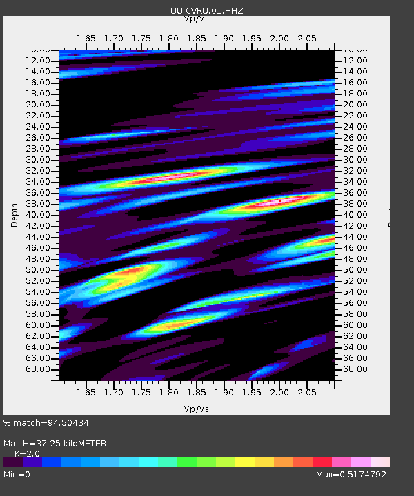
| Estimated Moho Depth: |
37.25 km |
| Estimated Crust Vp/Vs: |
2.00 |
| Assumed Crust Vp: |
6.207 km/s |
| Estimated Crust Vs: |
3.103 km/s |
| Estimated Crust Poisson's Ratio: |
0.33 |
|
| Radial Match: |
94.50434 % |
| Radial Bump: |
400 |
| Transverse Match: |
90.265785 % |
| Transverse Bump: |
400 |
| SOD ConfigId: |
2825771 |
| Insert Time: |
2018-09-11 22:56:17.753 +0000 |
| GWidth: |
2.5 |
| Max Bumps: |
400 |
| Tol: |
0.001 |
|
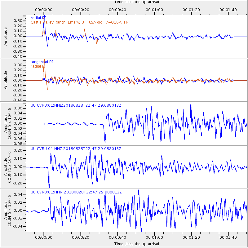
Signal To Noise
| Channel | StoN | STA | LTA |
| UU:CVRU:01:HHZ:20180828T22:47:29.088013Z | 59.854294 | 9.297788E-8 | 1.5534036E-9 |
| UU:CVRU:01:HHN:20180828T22:47:29.088013Z | 15.7228985 | 1.3522641E-8 | 8.600603E-10 |
| UU:CVRU:01:HHE:20180828T22:47:29.088013Z | 11.152475 | 2.7399066E-8 | 2.45677E-9 |
| Arrivals |
| Ps | 6.1 SECOND |
| PpPs | 18 SECOND |
| PsPs/PpSs | 24 SECOND |


