You are here: Home > Network List > TX - Texas Seismological Network Stations List
> Station WTFS Witchita Falls > Earthquake Result Viewer
WTFS Witchita Falls - Earthquake Result Viewer
| Earthquake location: |
Near Coast Of Ecuador |
| Earthquake latitude/longitude: |
-0.2/-80.7 |
| Earthquake time(UTC): |
2022/08/21 (233) 10:28:00 GMT |
| Earthquake Depth: |
10 km |
| Earthquake Magnitude: |
5.5 mww |
| Earthquake Catalog/Contributor: |
NEIC PDE/us |
|
| Network: |
TX Texas Seismological Network |
| Station: |
WTFS Witchita Falls |
| Lat/Lon: |
33.77 N/98.46 W |
| Elevation: |
277 m |
|
| Distance: |
37.7 deg |
| Az: |
335.455 deg |
| Baz: |
150.088 deg |
| Ray Param: |
0.075982556 |
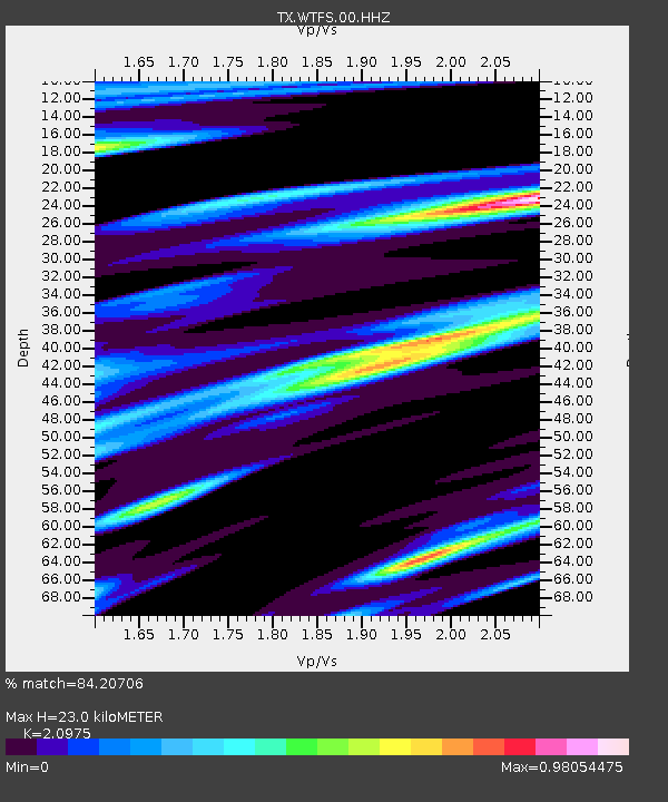
| Estimated Moho Depth: |
23.0 km |
| Estimated Crust Vp/Vs: |
2.10 |
| Assumed Crust Vp: |
6.426 km/s |
| Estimated Crust Vs: |
3.064 km/s |
| Estimated Crust Poisson's Ratio: |
0.35 |
|
| Radial Match: |
84.20706 % |
| Radial Bump: |
303 |
| Transverse Match: |
64.272 % |
| Transverse Bump: |
340 |
| SOD ConfigId: |
28764291 |
| Insert Time: |
2022-09-04 10:55:41.192 +0000 |
| GWidth: |
2.5 |
| Max Bumps: |
400 |
| Tol: |
0.001 |
|
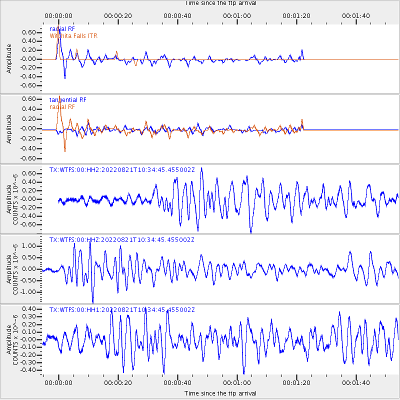
Signal To Noise
| Channel | StoN | STA | LTA |
| TX:WTFS:00:HHZ:20220821T10:34:45.455002Z | 3.7155738 | 2.473961E-7 | 6.6583546E-8 |
| TX:WTFS:00:HH1:20220821T10:34:45.455002Z | 0.8750606 | 7.904851E-8 | 9.033489E-8 |
| TX:WTFS:00:HH2:20220821T10:34:45.455002Z | 2.4642642 | 1.4307933E-7 | 5.806169E-8 |
| Arrivals |
| Ps | 4.2 SECOND |
| PpPs | 10 SECOND |
| PsPs/PpSs | 15 SECOND |


