You are here: Home > Network List > AK - Alaska Regional Network Stations List
> Station G17K Kiwalik Mountain, AK, USA > Earthquake Result Viewer
G17K Kiwalik Mountain, AK, USA - Earthquake Result Viewer
| Earthquake location: |
Southern Sumatra, Indonesia |
| Earthquake latitude/longitude: |
-5.1/103.1 |
| Earthquake time(UTC): |
2022/08/23 (235) 14:31:40 GMT |
| Earthquake Depth: |
59 km |
| Earthquake Magnitude: |
6.0 Mww |
| Earthquake Catalog/Contributor: |
NEIC PDE/us |
|
| Network: |
AK Alaska Regional Network |
| Station: |
G17K Kiwalik Mountain, AK, USA |
| Lat/Lon: |
65.50 N/160.65 W |
| Elevation: |
338 m |
|
| Distance: |
97.2 deg |
| Az: |
24.695 deg |
| Baz: |
273.576 deg |
| Ray Param: |
0.040254533 |
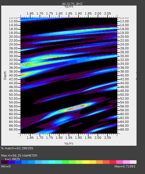
| Estimated Moho Depth: |
56.25 km |
| Estimated Crust Vp/Vs: |
1.89 |
| Assumed Crust Vp: |
6.276 km/s |
| Estimated Crust Vs: |
3.316 km/s |
| Estimated Crust Poisson's Ratio: |
0.31 |
|
| Radial Match: |
82.299255 % |
| Radial Bump: |
400 |
| Transverse Match: |
66.05957 % |
| Transverse Bump: |
400 |
| SOD ConfigId: |
28764291 |
| Insert Time: |
2022-09-06 14:35:49.723 +0000 |
| GWidth: |
2.5 |
| Max Bumps: |
400 |
| Tol: |
0.001 |
|

Signal To Noise
| Channel | StoN | STA | LTA |
| AK:G17K: :BHZ:20220823T14:44:35.640025Z | 13.139658 | 1.023564E-6 | 7.789883E-8 |
| AK:G17K: :BHN:20220823T14:44:35.640025Z | 2.7064066 | 2.0914428E-7 | 7.727748E-8 |
| AK:G17K: :BHE:20220823T14:44:35.640025Z | 5.6192255 | 3.2815404E-7 | 5.839845E-8 |
| Arrivals |
| Ps | 8.1 SECOND |
| PpPs | 25 SECOND |
| PsPs/PpSs | 34 SECOND |


