You are here: Home > Network List > GE - GEOFON Stations List
> Station EIL GEOFON Station Eilat, Israel > Earthquake Result Viewer
EIL GEOFON Station Eilat, Israel - Earthquake Result Viewer
| Earthquake location: |
Southern Sumatra, Indonesia |
| Earthquake latitude/longitude: |
-5.1/103.1 |
| Earthquake time(UTC): |
2022/08/23 (235) 14:31:40 GMT |
| Earthquake Depth: |
59 km |
| Earthquake Magnitude: |
6.0 Mww |
| Earthquake Catalog/Contributor: |
NEIC PDE/us |
|
| Network: |
GE GEOFON |
| Station: |
EIL GEOFON Station Eilat, Israel |
| Lat/Lon: |
29.67 N/34.95 E |
| Elevation: |
210 m |
|
| Distance: |
73.8 deg |
| Az: |
302.723 deg |
| Baz: |
105.653 deg |
| Ray Param: |
0.052669298 |
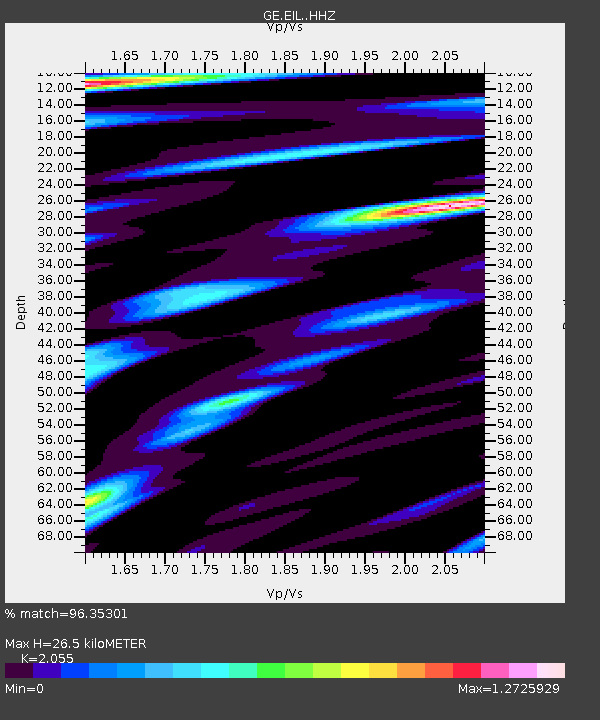
| Estimated Moho Depth: |
26.5 km |
| Estimated Crust Vp/Vs: |
2.06 |
| Assumed Crust Vp: |
6.472 km/s |
| Estimated Crust Vs: |
3.149 km/s |
| Estimated Crust Poisson's Ratio: |
0.34 |
|
| Radial Match: |
96.35301 % |
| Radial Bump: |
400 |
| Transverse Match: |
93.66491 % |
| Transverse Bump: |
400 |
| SOD ConfigId: |
28764291 |
| Insert Time: |
2022-09-06 14:41:01.688 +0000 |
| GWidth: |
2.5 |
| Max Bumps: |
400 |
| Tol: |
0.001 |
|

Signal To Noise
| Channel | StoN | STA | LTA |
| GE:EIL: :HHZ:20220823T14:42:38.07899Z | 33.607918 | 2.7792626E-6 | 8.2696666E-8 |
| GE:EIL: :HHN:20220823T14:42:38.07899Z | 6.132079 | 4.047737E-7 | 6.600921E-8 |
| GE:EIL: :HHE:20220823T14:42:38.07899Z | 12.4486885 | 8.9402187E-7 | 7.181655E-8 |
| Arrivals |
| Ps | 4.4 SECOND |
| PpPs | 12 SECOND |
| PsPs/PpSs | 17 SECOND |


