You are here: Home > Network List > GO - National Seismic Network of Georgia Stations List
> Station MINA Georgia, Mina > Earthquake Result Viewer
MINA Georgia, Mina - Earthquake Result Viewer
| Earthquake location: |
Southern Sumatra, Indonesia |
| Earthquake latitude/longitude: |
-5.1/103.1 |
| Earthquake time(UTC): |
2022/08/23 (235) 14:31:40 GMT |
| Earthquake Depth: |
59 km |
| Earthquake Magnitude: |
6.0 Mww |
| Earthquake Catalog/Contributor: |
NEIC PDE/us |
|
| Network: |
GO National Seismic Network of Georgia |
| Station: |
MINA Georgia, Mina |
| Lat/Lon: |
41.60 N/43.02 E |
| Elevation: |
1568 m |
|
| Distance: |
71.7 deg |
| Az: |
316.775 deg |
| Baz: |
114.556 deg |
| Ray Param: |
0.05406102 |
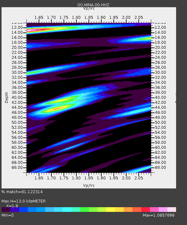
| Estimated Moho Depth: |
13.0 km |
| Estimated Crust Vp/Vs: |
1.60 |
| Assumed Crust Vp: |
6.419 km/s |
| Estimated Crust Vs: |
4.012 km/s |
| Estimated Crust Poisson's Ratio: |
0.18 |
|
| Radial Match: |
81.122314 % |
| Radial Bump: |
361 |
| Transverse Match: |
70.95422 % |
| Transverse Bump: |
322 |
| SOD ConfigId: |
28764291 |
| Insert Time: |
2022-09-06 14:41:20.339 +0000 |
| GWidth: |
2.5 |
| Max Bumps: |
400 |
| Tol: |
0.001 |
|

Signal To Noise
| Channel | StoN | STA | LTA |
| GO:MINA:00:HHZ:20220823T14:42:25.609996Z | 41.75678 | 3.1000811E-6 | 7.4241385E-8 |
| GO:MINA:00:HHN:20220823T14:42:25.609996Z | 4.4022818 | 2.408682E-7 | 5.47144E-8 |
| GO:MINA:00:HHE:20220823T14:42:25.609996Z | 23.445614 | 8.85224E-7 | 3.7756486E-8 |
| Arrivals |
| Ps | 1.3 SECOND |
| PpPs | 5.1 SECOND |
| PsPs/PpSs | 6.3 SECOND |


