You are here: Home > Network List > GS - US Geological Survey Networks Stations List
> Station OK051 E0350 and S34600 Roads, Ralston, OK > Earthquake Result Viewer
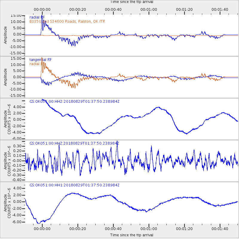
OK051 E0350 and S34600 Roads, Ralston, OK - Earthquake Result Viewer
*The percent match for this event was below the threshold and hence no stack was calculated.
| Earthquake location: |
Fiji Islands |
| Earthquake latitude/longitude: |
-16.4/178.0 |
| Earthquake time(UTC): |
2018/08/29 (241) 01:24:55 GMT |
| Earthquake Depth: |
10 km |
| Earthquake Magnitude: |
5.7 mb |
| Earthquake Catalog/Contributor: |
NEIC PDE/us |
|
| Network: |
GS US Geological Survey Networks |
| Station: |
OK051 E0350 and S34600 Roads, Ralston, OK |
| Lat/Lon: |
36.51 N/96.84 W |
| Elevation: |
263 m |
|
| Distance: |
95.8 deg |
| Az: |
53.793 deg |
| Baz: |
254.005 deg |
| Ray Param: |
$rayparam |
*The percent match for this event was below the threshold and hence was not used in the summary stack. |
|
| Radial Match: |
76.98289 % |
| Radial Bump: |
395 |
| Transverse Match: |
69.90899 % |
| Transverse Bump: |
400 |
| SOD ConfigId: |
2825771 |
| Insert Time: |
2018-09-12 01:44:59.123 +0000 |
| GWidth: |
2.5 |
| Max Bumps: |
400 |
| Tol: |
0.001 |
|
Signal To Noise
| Channel | StoN | STA | LTA |
| GS:OK051:00:HHZ:20180829T01:37:50.238984Z | 1.2191739 | 1.3504851E-7 | 1.1077051E-7 |
| GS:OK051:00:HH1:20180829T01:37:50.238984Z | 3.8296204 | 7.4268582E-6 | 1.9393199E-6 |
| GS:OK051:00:HH2:20180829T01:37:50.238984Z | 2.1325116 | 5.673669E-6 | 2.6605571E-6 |
| Arrivals |
| Ps | |
| PpPs | |
| PsPs/PpSs | |


