You are here: Home > Network List > IU - Global Seismograph Network (GSN - IRIS/USGS) Stations List
> Station PMG Port Moresby, New Guinea > Earthquake Result Viewer
PMG Port Moresby, New Guinea - Earthquake Result Viewer

| Earthquake location: |
Southern Sumatra, Indonesia |
| Earthquake latitude/longitude: |
-5.1/103.1 |
| Earthquake time(UTC): |
2022/08/23 (235) 14:31:40 GMT |
| Earthquake Depth: |
59 km |
| Earthquake Magnitude: |
6.0 Mww |
| Earthquake Catalog/Contributor: |
NEIC PDE/us |
|
| Network: |
IU Global Seismograph Network (GSN - IRIS/USGS) |
| Station: |
PMG Port Moresby, New Guinea |
| Lat/Lon: |
9.40 S/147.16 E |
| Elevation: |
90 m |
|
| Distance: |
43.9 deg |
| Az: |
98.242 deg |
| Baz: |
272.438 deg |
| Ray Param: |
0.07210152 |
| Estimated Moho Depth: |
33.0 km |
| Estimated Crust Vp/Vs: |
1.73 |
| Assumed Crust Vp: |
6.122 km/s |
| Estimated Crust Vs: |
3.534 km/s |
| Estimated Crust Poisson's Ratio: |
0.25 |
|
| Radial Match: |
93.31719 % |
| Radial Bump: |
400 |
| Transverse Match: |
89.47507 % |
| Transverse Bump: |
400 |
| SOD ConfigId: |
28764291 |
| Insert Time: |
2022-09-06 14:42:46.522 +0000 |
| GWidth: |
2.5 |
| Max Bumps: |
400 |
| Tol: |
0.001 |
|
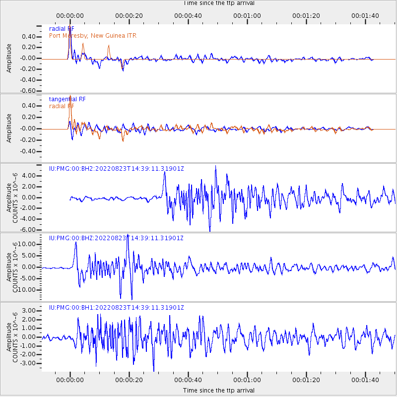
Signal To Noise
| Channel | StoN | STA | LTA |
| IU:PMG:00:BHZ:20220823T14:39:11.31901Z | 40.26692 | 4.8260854E-6 | 1.1985236E-7 |
| IU:PMG:00:BH1:20220823T14:39:11.31901Z | 5.515911 | 8.3229577E-7 | 1.5088999E-7 |
| IU:PMG:00:BH2:20220823T14:39:11.31901Z | 9.497648 | 1.9373038E-6 | 2.0397721E-7 |
| Arrivals |
| Ps | 4.2 SECOND |
| PpPs | 14 SECOND |
| PsPs/PpSs | 18 SECOND |


