You are here: Home > Network List > UU - University of Utah Regional Network Stations List
> Station SVWY Solvay Mine, WY, USA > Earthquake Result Viewer
SVWY Solvay Mine, WY, USA - Earthquake Result Viewer
| Earthquake location: |
Fiji Islands |
| Earthquake latitude/longitude: |
-16.4/178.0 |
| Earthquake time(UTC): |
2018/08/29 (241) 01:24:55 GMT |
| Earthquake Depth: |
10 km |
| Earthquake Magnitude: |
5.7 mb |
| Earthquake Catalog/Contributor: |
NEIC PDE/us |
|
| Network: |
UU University of Utah Regional Network |
| Station: |
SVWY Solvay Mine, WY, USA |
| Lat/Lon: |
41.45 N/109.86 W |
| Elevation: |
1950 m |
|
| Distance: |
87.9 deg |
| Az: |
45.713 deg |
| Baz: |
246.073 deg |
| Ray Param: |
0.04299284 |
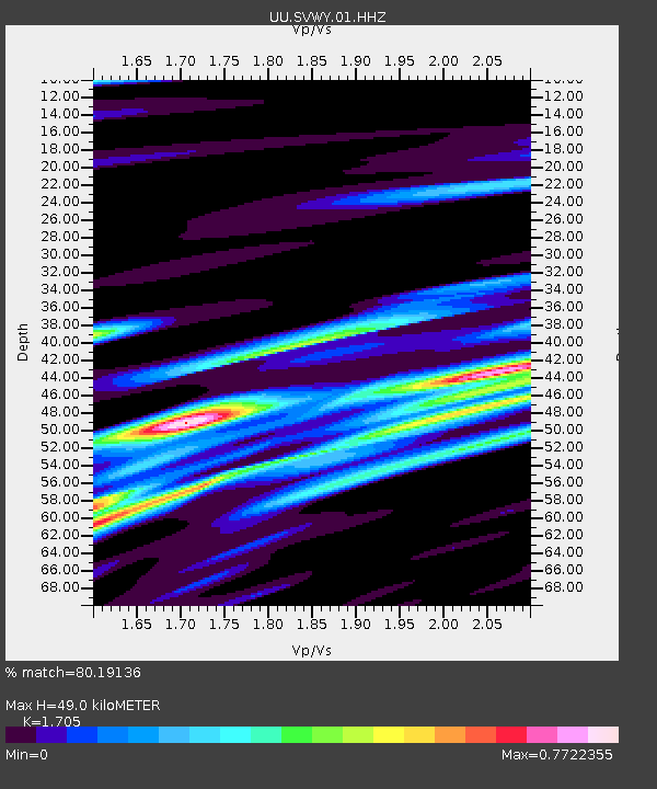
| Estimated Moho Depth: |
49.0 km |
| Estimated Crust Vp/Vs: |
1.71 |
| Assumed Crust Vp: |
6.207 km/s |
| Estimated Crust Vs: |
3.64 km/s |
| Estimated Crust Poisson's Ratio: |
0.24 |
|
| Radial Match: |
80.19136 % |
| Radial Bump: |
400 |
| Transverse Match: |
72.4641 % |
| Transverse Bump: |
400 |
| SOD ConfigId: |
2825771 |
| Insert Time: |
2018-09-12 01:48:27.571 +0000 |
| GWidth: |
2.5 |
| Max Bumps: |
400 |
| Tol: |
0.001 |
|

Signal To Noise
| Channel | StoN | STA | LTA |
| UU:SVWY:01:HHZ:20180829T01:37:13.899019Z | 1.9143848 | 5.9886807E-9 | 3.1282532E-9 |
| UU:SVWY:01:HHN:20180829T01:37:13.899019Z | 0.9739219 | 2.1704114E-9 | 2.2285274E-9 |
| UU:SVWY:01:HHE:20180829T01:37:13.899019Z | 0.7668898 | 1.3050082E-9 | 1.7016892E-9 |
| Arrivals |
| Ps | 5.7 SECOND |
| PpPs | 21 SECOND |
| PsPs/PpSs | 27 SECOND |


