You are here: Home > Network List > TX - Texas Seismological Network Stations List
> Station PB06 Permian Basin 6 > Earthquake Result Viewer
PB06 Permian Basin 6 - Earthquake Result Viewer
| Earthquake location: |
Chile-Bolivia Border Region |
| Earthquake latitude/longitude: |
-22.0/-68.5 |
| Earthquake time(UTC): |
2022/08/24 (236) 12:09:45 GMT |
| Earthquake Depth: |
108 km |
| Earthquake Magnitude: |
5.4 Mww |
| Earthquake Catalog/Contributor: |
NEIC PDE/us |
|
| Network: |
TX Texas Seismological Network |
| Station: |
PB06 Permian Basin 6 |
| Lat/Lon: |
31.65 N/103.22 W |
| Elevation: |
831 m |
|
| Distance: |
62.8 deg |
| Az: |
326.913 deg |
| Baz: |
143.55 deg |
| Ray Param: |
0.059667494 |
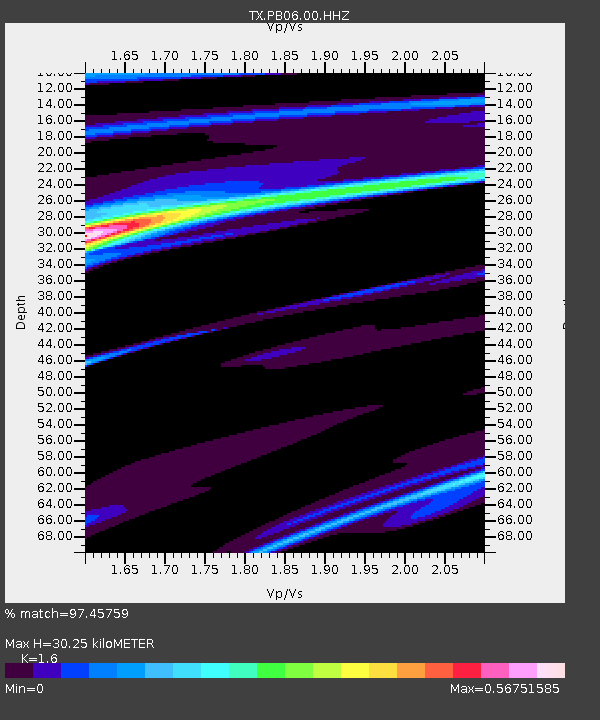
| Estimated Moho Depth: |
30.25 km |
| Estimated Crust Vp/Vs: |
1.60 |
| Assumed Crust Vp: |
6.121 km/s |
| Estimated Crust Vs: |
3.825 km/s |
| Estimated Crust Poisson's Ratio: |
0.18 |
|
| Radial Match: |
97.45759 % |
| Radial Bump: |
144 |
| Transverse Match: |
81.256424 % |
| Transverse Bump: |
400 |
| SOD ConfigId: |
28764291 |
| Insert Time: |
2022-09-07 12:48:33.763 +0000 |
| GWidth: |
2.5 |
| Max Bumps: |
400 |
| Tol: |
0.001 |
|

Signal To Noise
| Channel | StoN | STA | LTA |
| TX:PB06:00:HHZ:20220824T12:19:29.539989Z | 1.2165064 | 2.199021E-6 | 1.8076528E-6 |
| TX:PB06:00:HH1:20220824T12:19:29.539989Z | 1.292114 | 2.6717264E-6 | 2.0677173E-6 |
| TX:PB06:00:HH2:20220824T12:19:29.539989Z | 1.2659086 | 1.5098752E-6 | 1.1927206E-6 |
| Arrivals |
| Ps | 3.1 SECOND |
| PpPs | 12 SECOND |
| PsPs/PpSs | 15 SECOND |


