You are here: Home > Network List > IU - Global Seismograph Network (GSN - IRIS/USGS) Stations List
> Station POHA Pohakuloa, Hawaii, USA > Earthquake Result Viewer
POHA Pohakuloa, Hawaii, USA - Earthquake Result Viewer
| Earthquake location: |
Southeast Of Loyalty Islands |
| Earthquake latitude/longitude: |
-22.2/170.0 |
| Earthquake time(UTC): |
2018/08/29 (241) 03:51:55 GMT |
| Earthquake Depth: |
10 km |
| Earthquake Magnitude: |
7.0 Mi |
| Earthquake Catalog/Contributor: |
NEIC PDE/pt |
|
| Network: |
IU Global Seismograph Network (GSN - IRIS/USGS) |
| Station: |
POHA Pohakuloa, Hawaii, USA |
| Lat/Lon: |
19.76 N/155.53 W |
| Elevation: |
1990 m |
|
| Distance: |
53.6 deg |
| Az: |
41.495 deg |
| Baz: |
220.692 deg |
| Ray Param: |
0.06598629 |
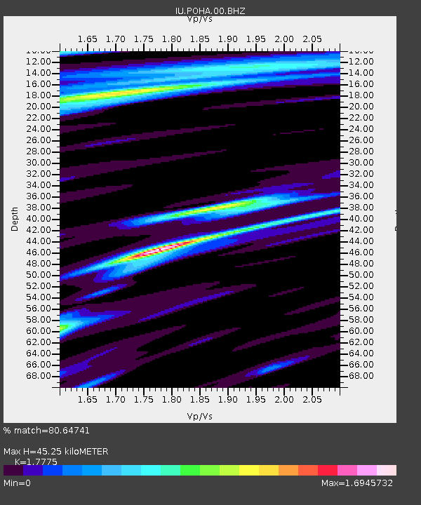
| Estimated Moho Depth: |
45.25 km |
| Estimated Crust Vp/Vs: |
1.78 |
| Assumed Crust Vp: |
5.195 km/s |
| Estimated Crust Vs: |
2.923 km/s |
| Estimated Crust Poisson's Ratio: |
0.27 |
|
| Radial Match: |
80.64741 % |
| Radial Bump: |
400 |
| Transverse Match: |
57.42278 % |
| Transverse Bump: |
400 |
| SOD ConfigId: |
2825771 |
| Insert Time: |
2018-09-12 03:56:36.108 +0000 |
| GWidth: |
2.5 |
| Max Bumps: |
400 |
| Tol: |
0.001 |
|
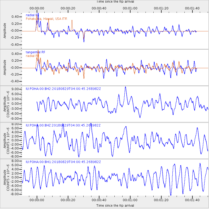
Signal To Noise
| Channel | StoN | STA | LTA |
| IU:POHA:00:BHZ:20180829T04:00:45.268982Z | 2.243409 | 3.8588923E-6 | 1.720102E-6 |
| IU:POHA:00:BH1:20180829T04:00:45.268982Z | 1.6237327 | 3.5665096E-6 | 2.1964881E-6 |
| IU:POHA:00:BH2:20180829T04:00:45.268982Z | 1.0168904 | 2.135822E-6 | 2.1003461E-6 |
| Arrivals |
| Ps | 7.0 SECOND |
| PpPs | 23 SECOND |
| PsPs/PpSs | 30 SECOND |


