You are here: Home > Network List > US - United States National Seismic Network Stations List
> Station TPNV Topopah Spring, Nevada, USA > Earthquake Result Viewer
TPNV Topopah Spring, Nevada, USA - Earthquake Result Viewer
| Earthquake location: |
Southeast Of Loyalty Islands |
| Earthquake latitude/longitude: |
-22.2/170.0 |
| Earthquake time(UTC): |
2018/08/29 (241) 03:51:55 GMT |
| Earthquake Depth: |
10 km |
| Earthquake Magnitude: |
7.0 Mi |
| Earthquake Catalog/Contributor: |
NEIC PDE/pt |
|
| Network: |
US United States National Seismic Network |
| Station: |
TPNV Topopah Spring, Nevada, USA |
| Lat/Lon: |
36.95 N/116.25 W |
| Elevation: |
1600 m |
|
| Distance: |
91.0 deg |
| Az: |
50.292 deg |
| Baz: |
242.878 deg |
| Ray Param: |
0.04163406 |
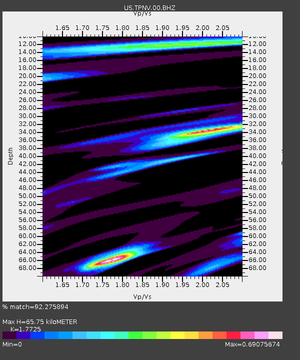
| Estimated Moho Depth: |
65.75 km |
| Estimated Crust Vp/Vs: |
1.77 |
| Assumed Crust Vp: |
6.279 km/s |
| Estimated Crust Vs: |
3.542 km/s |
| Estimated Crust Poisson's Ratio: |
0.27 |
|
| Radial Match: |
92.275894 % |
| Radial Bump: |
400 |
| Transverse Match: |
86.91255 % |
| Transverse Bump: |
400 |
| SOD ConfigId: |
2825771 |
| Insert Time: |
2018-09-12 03:58:11.349 +0000 |
| GWidth: |
2.5 |
| Max Bumps: |
400 |
| Tol: |
0.001 |
|
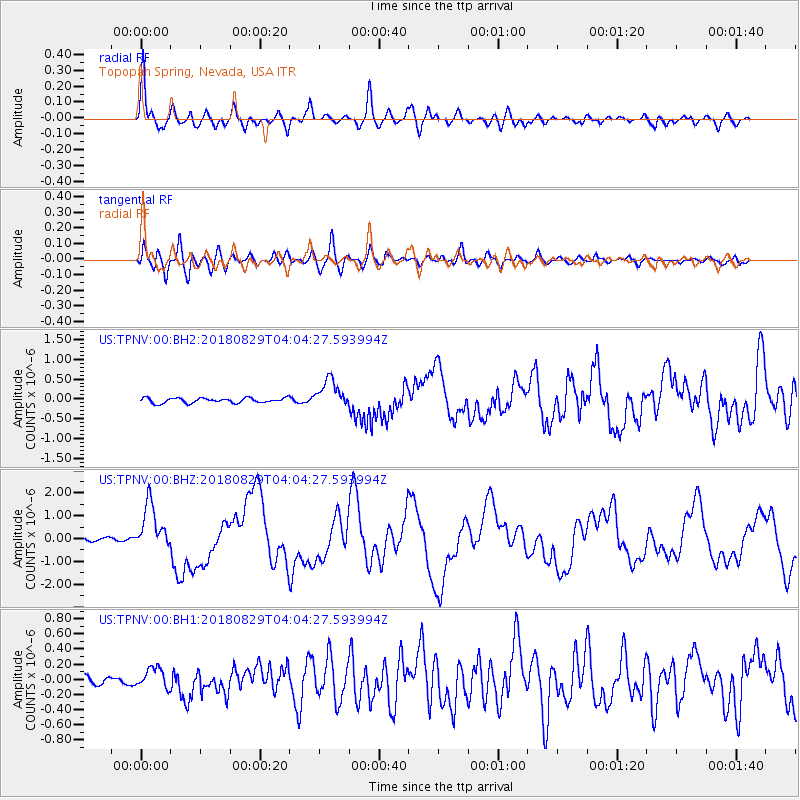
Signal To Noise
| Channel | StoN | STA | LTA |
| US:TPNV:00:BHZ:20180829T04:04:27.593994Z | 16.632334 | 1.0225233E-6 | 6.147804E-8 |
| US:TPNV:00:BH1:20180829T04:04:27.593994Z | 1.8458989 | 1.2623438E-7 | 6.8386406E-8 |
| US:TPNV:00:BH2:20180829T04:04:27.593994Z | 5.764775 | 3.5795273E-7 | 6.209309E-8 |
| Arrivals |
| Ps | 8.3 SECOND |
| PpPs | 28 SECOND |
| PsPs/PpSs | 37 SECOND |


