You are here: Home > Network List > TX - Texas Seismological Network Stations List
> Station PB28 Culberson South > Earthquake Result Viewer
PB28 Culberson South - Earthquake Result Viewer
| Earthquake location: |
Fiji Islands Region |
| Earthquake latitude/longitude: |
-21.8/-176.8 |
| Earthquake time(UTC): |
2022/08/28 (240) 18:48:01 GMT |
| Earthquake Depth: |
221 km |
| Earthquake Magnitude: |
5.6 mww |
| Earthquake Catalog/Contributor: |
NEIC PDE/us |
|
| Network: |
TX Texas Seismological Network |
| Station: |
PB28 Culberson South |
| Lat/Lon: |
31.67 N/104.50 W |
| Elevation: |
1204 m |
|
| Distance: |
87.3 deg |
| Az: |
54.408 deg |
| Baz: |
242.395 deg |
| Ray Param: |
0.04294011 |
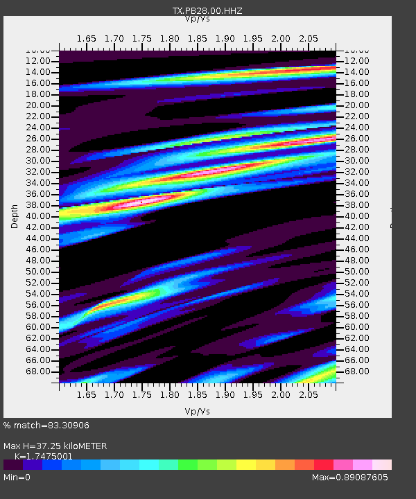
| Estimated Moho Depth: |
37.25 km |
| Estimated Crust Vp/Vs: |
1.75 |
| Assumed Crust Vp: |
6.361 km/s |
| Estimated Crust Vs: |
3.64 km/s |
| Estimated Crust Poisson's Ratio: |
0.26 |
|
| Radial Match: |
83.30906 % |
| Radial Bump: |
400 |
| Transverse Match: |
69.8411 % |
| Transverse Bump: |
400 |
| SOD ConfigId: |
28764291 |
| Insert Time: |
2022-09-11 19:10:38.408 +0000 |
| GWidth: |
2.5 |
| Max Bumps: |
400 |
| Tol: |
0.001 |
|

Signal To Noise
| Channel | StoN | STA | LTA |
| TX:PB28:00:HHZ:20220828T18:59:51.14001Z | 1.0712249 | 9.028519E-8 | 8.42822E-8 |
| TX:PB28:00:HH1:20220828T18:59:51.14001Z | 1.2745001 | 7.159985E-8 | 5.6178767E-8 |
| TX:PB28:00:HH2:20220828T18:59:51.14001Z | 1.1326938 | 7.4421436E-8 | 6.570305E-8 |
| Arrivals |
| Ps | 4.5 SECOND |
| PpPs | 16 SECOND |
| PsPs/PpSs | 20 SECOND |


