You are here: Home > Network List > UW - Pacific Northwest Regional Seismic Network Stations List
> Station HOOD Mt Hood Meadows, OR CREST BB SMO > Earthquake Result Viewer
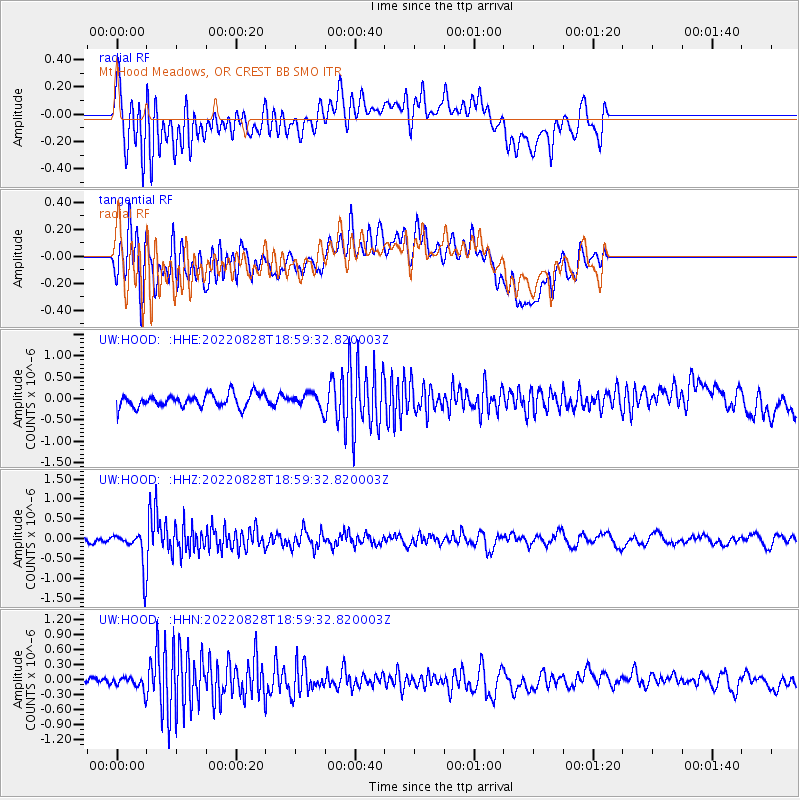
HOOD Mt Hood Meadows, OR CREST BB SMO - Earthquake Result Viewer
*The percent match for this event was below the threshold and hence no stack was calculated.
| Earthquake location: |
Fiji Islands Region |
| Earthquake latitude/longitude: |
-21.8/-176.8 |
| Earthquake time(UTC): |
2022/08/28 (240) 18:48:01 GMT |
| Earthquake Depth: |
221 km |
| Earthquake Magnitude: |
5.6 mww |
| Earthquake Catalog/Contributor: |
NEIC PDE/us |
|
| Network: |
UW Pacific Northwest Regional Seismic Network |
| Station: |
HOOD Mt Hood Meadows, OR CREST BB SMO |
| Lat/Lon: |
45.32 N/121.65 W |
| Elevation: |
1520 m |
|
| Distance: |
83.5 deg |
| Az: |
35.633 deg |
| Baz: |
230.112 deg |
| Ray Param: |
$rayparam |
*The percent match for this event was below the threshold and hence was not used in the summary stack. |
|
| Radial Match: |
61.040585 % |
| Radial Bump: |
400 |
| Transverse Match: |
52.314648 % |
| Transverse Bump: |
400 |
| SOD ConfigId: |
28764291 |
| Insert Time: |
2022-09-11 19:12:34.330 +0000 |
| GWidth: |
2.5 |
| Max Bumps: |
400 |
| Tol: |
0.001 |
|
Signal To Noise
| Channel | StoN | STA | LTA |
| UW:HOOD: :HHZ:20220828T18:59:32.820003Z | 5.7057595 | 4.470024E-7 | 7.834231E-8 |
| UW:HOOD: :HHN:20220828T18:59:32.820003Z | 1.011531 | 1.2484209E-7 | 1.2341896E-7 |
| UW:HOOD: :HHE:20220828T18:59:32.820003Z | 1.0736136 | 1.6720463E-7 | 1.5574004E-7 |
| Arrivals |
| Ps | |
| PpPs | |
| PsPs/PpSs | |


