You are here: Home > Network List > UU - University of Utah Regional Network Stations List
> Station CVRU Castle Valley Ranch, Emery, UT, USA old TA-Q16A > Earthquake Result Viewer
CVRU Castle Valley Ranch, Emery, UT, USA old TA-Q16A - Earthquake Result Viewer
| Earthquake location: |
Southeast Of Loyalty Islands |
| Earthquake latitude/longitude: |
-22.2/170.0 |
| Earthquake time(UTC): |
2018/08/29 (241) 03:51:55 GMT |
| Earthquake Depth: |
10 km |
| Earthquake Magnitude: |
7.0 Mi |
| Earthquake Catalog/Contributor: |
NEIC PDE/pt |
|
| Network: |
UU University of Utah Regional Network |
| Station: |
CVRU Castle Valley Ranch, Emery, UT, USA old TA-Q16A |
| Lat/Lon: |
38.92 N/111.17 W |
| Elevation: |
1912 m |
|
| Distance: |
95.5 deg |
| Az: |
50.253 deg |
| Baz: |
245.99 deg |
| Ray Param: |
0.040776882 |
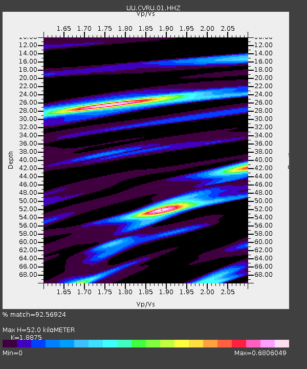
| Estimated Moho Depth: |
52.0 km |
| Estimated Crust Vp/Vs: |
1.89 |
| Assumed Crust Vp: |
6.207 km/s |
| Estimated Crust Vs: |
3.288 km/s |
| Estimated Crust Poisson's Ratio: |
0.30 |
|
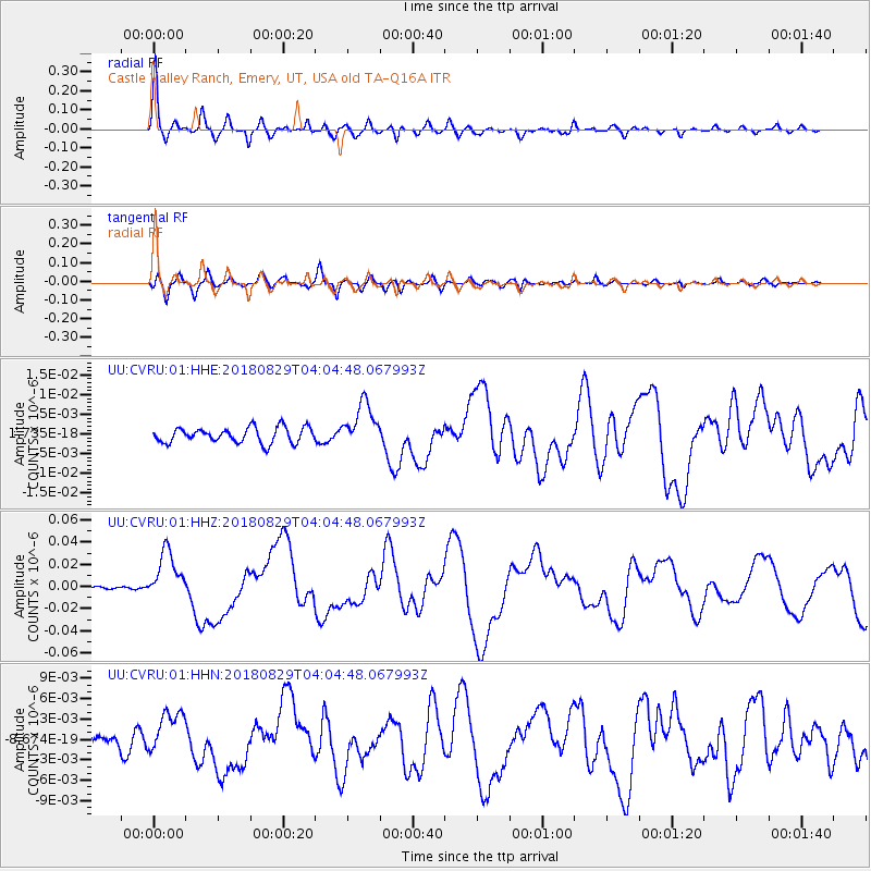
| Radial Match: |
92.56924 % |
| Radial Bump: |
385 |
| Transverse Match: |
80.90736 % |
| Transverse Bump: |
400 |
| SOD ConfigId: |
2825771 |
| Insert Time: |
2018-09-12 03:58:34.855 +0000 |
| GWidth: |
2.5 |
| Max Bumps: |
400 |
| Tol: |
0.001 |
|
Signal To Noise
| Channel | StoN | STA | LTA |
| UU:CVRU:01:HHZ:20180829T04:04:48.067993Z | 16.264544 | 2.2135954E-8 | 1.3609944E-9 |
| UU:CVRU:01:HHN:20180829T04:04:48.067993Z | 2.382809 | 3.429E-9 | 1.4390579E-9 |
| UU:CVRU:01:HHE:20180829T04:04:48.067993Z | 2.9491482 | 5.6517404E-9 | 1.9163975E-9 |
| Arrivals |
| Ps | 7.6 SECOND |
| PpPs | 24 SECOND |
| PsPs/PpSs | 31 SECOND |


