You are here: Home > Network List > AV - Alaska Volcano Observatory Stations List
> Station MAPS Pakushin Southeast, Makushin Volcano, Alaska > Earthquake Result Viewer
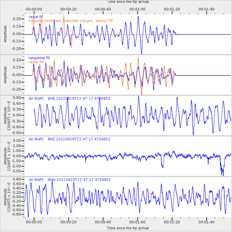
MAPS Pakushin Southeast, Makushin Volcano, Alaska - Earthquake Result Viewer
*The percent match for this event was below the threshold and hence no stack was calculated.
| Earthquake location: |
Southern Sumatra, Indonesia |
| Earthquake latitude/longitude: |
-1.0/98.6 |
| Earthquake time(UTC): |
2022/08/28 (240) 22:34:33 GMT |
| Earthquake Depth: |
12 km |
| Earthquake Magnitude: |
5.8 Mww |
| Earthquake Catalog/Contributor: |
NEIC PDE/us |
|
| Network: |
AV Alaska Volcano Observatory |
| Station: |
MAPS Pakushin Southeast, Makushin Volcano, Alaska |
| Lat/Lon: |
53.81 N/166.94 W |
| Elevation: |
333 m |
|
| Distance: |
93.4 deg |
| Az: |
36.326 deg |
| Baz: |
272.96 deg |
| Ray Param: |
$rayparam |
*The percent match for this event was below the threshold and hence was not used in the summary stack. |
|
| Radial Match: |
55.176746 % |
| Radial Bump: |
400 |
| Transverse Match: |
55.5313 % |
| Transverse Bump: |
400 |
| SOD ConfigId: |
28764291 |
| Insert Time: |
2022-09-11 22:38:06.483 +0000 |
| GWidth: |
2.5 |
| Max Bumps: |
400 |
| Tol: |
0.001 |
|
Signal To Noise
| Channel | StoN | STA | LTA |
| AV:MAPS: :BHZ:20220828T22:47:17.479985Z | 0.6241993 | 4.5749323E-7 | 7.3292824E-7 |
| AV:MAPS: :BHN:20220828T22:47:17.479985Z | 1.9161668 | 4.1098986E-7 | 2.1448542E-7 |
| AV:MAPS: :BHE:20220828T22:47:17.479985Z | 0.5874833 | 2.1191963E-7 | 3.6072453E-7 |
| Arrivals |
| Ps | |
| PpPs | |
| PsPs/PpSs | |


