You are here: Home > Network List > KO - Kandilli Observatory Digital Broadband Seismic Network Stations List
> Station GURO KO.GURO > Earthquake Result Viewer
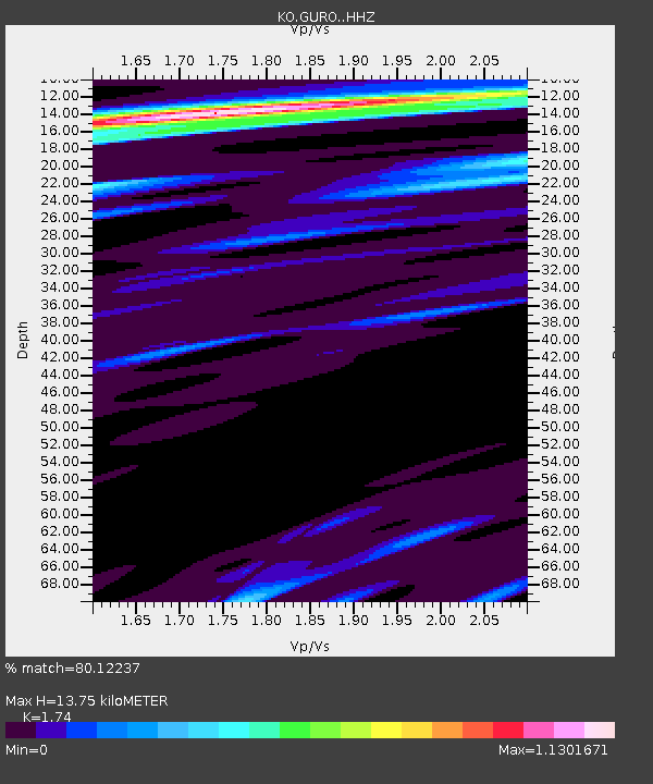
GURO KO.GURO - Earthquake Result Viewer
| Earthquake location: |
Southern Sumatra, Indonesia |
| Earthquake latitude/longitude: |
-1.0/98.6 |
| Earthquake time(UTC): |
2022/08/28 (240) 22:34:33 GMT |
| Earthquake Depth: |
12 km |
| Earthquake Magnitude: |
5.8 Mww |
| Earthquake Catalog/Contributor: |
NEIC PDE/us |
|
| Network: |
KO Kandilli Observatory Digital Broadband Seismic Network |
| Station: |
GURO KO.GURO |
| Lat/Lon: |
38.55 N/42.03 E |
| Elevation: |
1388 m |
|
| Distance: |
65.1 deg |
| Az: |
313.823 deg |
| Baz: |
113.073 deg |
| Ray Param: |
0.058471665 |
| Estimated Moho Depth: |
13.75 km |
| Estimated Crust Vp/Vs: |
1.74 |
| Assumed Crust Vp: |
6.35 km/s |
| Estimated Crust Vs: |
3.649 km/s |
| Estimated Crust Poisson's Ratio: |
0.25 |
|
| Radial Match: |
80.12237 % |
| Radial Bump: |
400 |
| Transverse Match: |
51.049637 % |
| Transverse Bump: |
400 |
| SOD ConfigId: |
28764291 |
| Insert Time: |
2022-09-11 22:41:48.364 +0000 |
| GWidth: |
2.5 |
| Max Bumps: |
400 |
| Tol: |
0.001 |
|

Signal To Noise
| Channel | StoN | STA | LTA |
| KO:GURO: :HHZ:20220828T22:44:43.339971Z | 6.5878224 | 1.8558487E-7 | 2.8170899E-8 |
| KO:GURO: :HHN:20220828T22:44:43.339971Z | 0.9498959 | 1.11825E-7 | 1.17723424E-7 |
| KO:GURO: :HHE:20220828T22:44:43.339971Z | 2.7135909 | 9.51255E-8 | 3.5055212E-8 |
| Arrivals |
| Ps | 1.7 SECOND |
| PpPs | 5.7 SECOND |
| PsPs/PpSs | 7.4 SECOND |


