You are here: Home > Network List > UU - University of Utah Regional Network Stations List
> Station FORU South Mineral Mountains, UT, USA > Earthquake Result Viewer
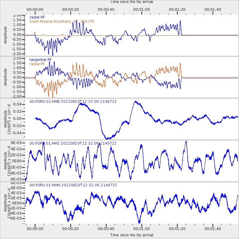
FORU South Mineral Mountains, UT, USA - Earthquake Result Viewer
*The percent match for this event was below the threshold and hence no stack was calculated.
| Earthquake location: |
Ryukyu Islands, Japan |
| Earthquake latitude/longitude: |
28.9/130.7 |
| Earthquake time(UTC): |
2022/08/29 (241) 12:19:35 GMT |
| Earthquake Depth: |
10 km |
| Earthquake Magnitude: |
5.6 Mww |
| Earthquake Catalog/Contributor: |
NEIC PDE/us |
|
| Network: |
UU University of Utah Regional Network |
| Station: |
FORU South Mineral Mountains, UT, USA |
| Lat/Lon: |
38.46 N/112.86 W |
| Elevation: |
1840 m |
|
| Distance: |
90.5 deg |
| Az: |
44.655 deg |
| Baz: |
308.264 deg |
| Ray Param: |
$rayparam |
*The percent match for this event was below the threshold and hence was not used in the summary stack. |
|
| Radial Match: |
81.693214 % |
| Radial Bump: |
400 |
| Transverse Match: |
79.40682 % |
| Transverse Bump: |
400 |
| SOD ConfigId: |
28764291 |
| Insert Time: |
2022-09-12 12:59:25.928 +0000 |
| GWidth: |
2.5 |
| Max Bumps: |
400 |
| Tol: |
0.001 |
|
Signal To Noise
| Channel | StoN | STA | LTA |
| UU:FORU:01:HHZ:20220829T12:32:06.214972Z | 1.1351669 | 3.1005376E-9 | 2.7313496E-9 |
| UU:FORU:01:HHN:20220829T12:32:06.214972Z | 1.7180154 | 4.2542845E-9 | 2.4762785E-9 |
| UU:FORU:01:HHE:20220829T12:32:06.214972Z | 2.2100394 | 3.104188E-8 | 1.4045849E-8 |
| Arrivals |
| Ps | |
| PpPs | |
| PsPs/PpSs | |


