You are here: Home > Network List > TM - Thai Seismic Monitoring Network Stations List
> Station PANO PANO staion > Earthquake Result Viewer
PANO PANO staion - Earthquake Result Viewer
| Earthquake location: |
Mariana Islands |
| Earthquake latitude/longitude: |
13.9/145.2 |
| Earthquake time(UTC): |
2022/08/29 (241) 12:55:56 GMT |
| Earthquake Depth: |
113 km |
| Earthquake Magnitude: |
5.8 Mi |
| Earthquake Catalog/Contributor: |
NEIC PDE/pt |
|
| Network: |
TM Thai Seismic Monitoring Network |
| Station: |
PANO PANO staion |
| Lat/Lon: |
17.15 N/104.61 E |
| Elevation: |
136 m |
|
| Distance: |
39.2 deg |
| Az: |
280.194 deg |
| Baz: |
88.968 deg |
| Ray Param: |
0.07472775 |
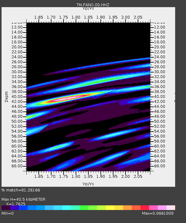
| Estimated Moho Depth: |
40.5 km |
| Estimated Crust Vp/Vs: |
1.76 |
| Assumed Crust Vp: |
6.498 km/s |
| Estimated Crust Vs: |
3.687 km/s |
| Estimated Crust Poisson's Ratio: |
0.26 |
|
| Radial Match: |
81.26166 % |
| Radial Bump: |
400 |
| Transverse Match: |
79.84948 % |
| Transverse Bump: |
400 |
| SOD ConfigId: |
28764291 |
| Insert Time: |
2022-09-12 13:22:19.198 +0000 |
| GWidth: |
2.5 |
| Max Bumps: |
400 |
| Tol: |
0.001 |
|

Signal To Noise
| Channel | StoN | STA | LTA |
| TM:PANO:00:HHZ:20220829T13:02:42.714996Z | 10.94069 | 1.0324307E-7 | 9.436614E-9 |
| TM:PANO:00:HHN:20220829T13:02:42.714996Z | 1.9891232 | 1.5458422E-8 | 7.771475E-9 |
| TM:PANO:00:HHE:20220829T13:02:42.714996Z | 2.4521148 | 2.2858599E-8 | 9.321994E-9 |
| Arrivals |
| Ps | 5.1 SECOND |
| PpPs | 16 SECOND |
| PsPs/PpSs | 21 SECOND |


