You are here: Home > Network List > IW - Intermountain West Stations List
> Station PLID Pearl Lake, Idaho, USA > Earthquake Result Viewer
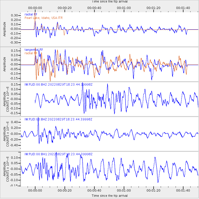
PLID Pearl Lake, Idaho, USA - Earthquake Result Viewer
*The percent match for this event was below the threshold and hence no stack was calculated.
| Earthquake location: |
South Of Kermadec Islands |
| Earthquake latitude/longitude: |
-32.7/-179.1 |
| Earthquake time(UTC): |
2022/08/29 (241) 18:10:50 GMT |
| Earthquake Depth: |
32 km |
| Earthquake Magnitude: |
5.8 mww |
| Earthquake Catalog/Contributor: |
NEIC PDE/us |
|
| Network: |
IW Intermountain West |
| Station: |
PLID Pearl Lake, Idaho, USA |
| Lat/Lon: |
45.09 N/116.00 W |
| Elevation: |
2164 m |
|
| Distance: |
96.3 deg |
| Az: |
39.442 deg |
| Baz: |
229.104 deg |
| Ray Param: |
$rayparam |
*The percent match for this event was below the threshold and hence was not used in the summary stack. |
|
| Radial Match: |
62.941208 % |
| Radial Bump: |
400 |
| Transverse Match: |
49.16882 % |
| Transverse Bump: |
400 |
| SOD ConfigId: |
28764291 |
| Insert Time: |
2022-09-12 18:24:27.292 +0000 |
| GWidth: |
2.5 |
| Max Bumps: |
400 |
| Tol: |
0.001 |
|
Signal To Noise
| Channel | StoN | STA | LTA |
| IW:PLID:00:BHZ:20220829T18:23:44.39998Z | 2.8540351 | 1.8747428E-7 | 6.568745E-8 |
| IW:PLID:00:BH1:20220829T18:23:44.39998Z | 1.2844573 | 4.2845095E-8 | 3.335657E-8 |
| IW:PLID:00:BH2:20220829T18:23:44.39998Z | 2.3300896 | 7.911565E-8 | 3.395391E-8 |
| Arrivals |
| Ps | |
| PpPs | |
| PsPs/PpSs | |


