You are here: Home > Network List > US - United States National Seismic Network Stations List
> Station EGMT Eagleton, Montana, USA > Earthquake Result Viewer
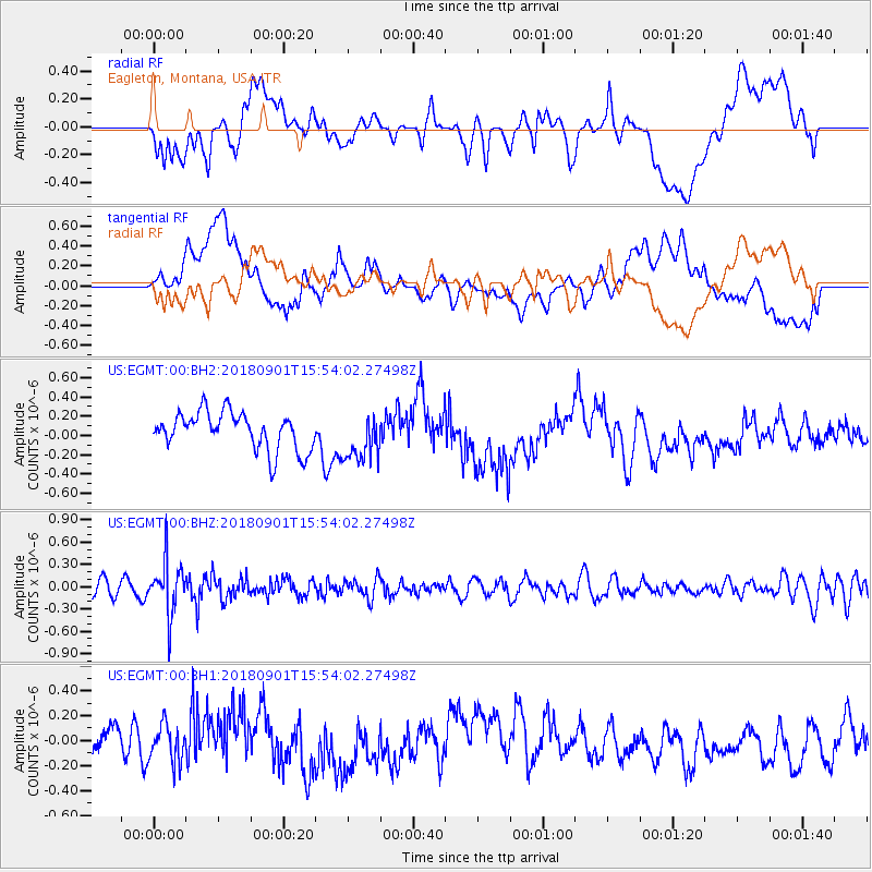
EGMT Eagleton, Montana, USA - Earthquake Result Viewer
*The percent match for this event was below the threshold and hence no stack was calculated.
| Earthquake location: |
Bonin Islands, Japan Region |
| Earthquake latitude/longitude: |
27.9/139.9 |
| Earthquake time(UTC): |
2018/09/01 (244) 15:43:02 GMT |
| Earthquake Depth: |
455 km |
| Earthquake Magnitude: |
5.6 Mww |
| Earthquake Catalog/Contributor: |
NEIC PDE/us |
|
| Network: |
US United States National Seismic Network |
| Station: |
EGMT Eagleton, Montana, USA |
| Lat/Lon: |
48.02 N/109.75 W |
| Elevation: |
1055 m |
|
| Distance: |
82.0 deg |
| Az: |
39.478 deg |
| Baz: |
303.065 deg |
| Ray Param: |
$rayparam |
*The percent match for this event was below the threshold and hence was not used in the summary stack. |
|
| Radial Match: |
39.649826 % |
| Radial Bump: |
400 |
| Transverse Match: |
42.674316 % |
| Transverse Bump: |
400 |
| SOD ConfigId: |
2825771 |
| Insert Time: |
2018-09-15 15:50:52.683 +0000 |
| GWidth: |
2.5 |
| Max Bumps: |
400 |
| Tol: |
0.001 |
|
Signal To Noise
| Channel | StoN | STA | LTA |
| US:EGMT:00:BHZ:20180901T15:54:02.27498Z | 3.6172044 | 3.5710391E-7 | 9.872373E-8 |
| US:EGMT:00:BH1:20180901T15:54:02.27498Z | 0.7361275 | 1.53216E-7 | 2.0813788E-7 |
| US:EGMT:00:BH2:20180901T15:54:02.27498Z | 1.3074675 | 2.543844E-7 | 1.9456269E-7 |
| Arrivals |
| Ps | |
| PpPs | |
| PsPs/PpSs | |


