You are here: Home > Network List > US - United States National Seismic Network Stations List
> Station WMOK Wichita Mountains, Oklahoma, USA > Earthquake Result Viewer
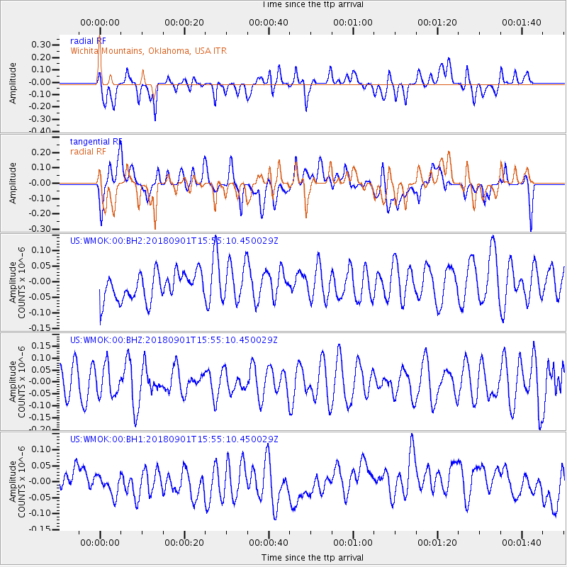
WMOK Wichita Mountains, Oklahoma, USA - Earthquake Result Viewer
*The percent match for this event was below the threshold and hence no stack was calculated.
| Earthquake location: |
Bonin Islands, Japan Region |
| Earthquake latitude/longitude: |
27.9/139.9 |
| Earthquake time(UTC): |
2018/09/01 (244) 15:43:02 GMT |
| Earthquake Depth: |
455 km |
| Earthquake Magnitude: |
5.6 Mww |
| Earthquake Catalog/Contributor: |
NEIC PDE/us |
|
| Network: |
US United States National Seismic Network |
| Station: |
WMOK Wichita Mountains, Oklahoma, USA |
| Lat/Lon: |
34.74 N/98.78 W |
| Elevation: |
486 m |
|
| Distance: |
96.6 deg |
| Az: |
45.113 deg |
| Baz: |
310.426 deg |
| Ray Param: |
$rayparam |
*The percent match for this event was below the threshold and hence was not used in the summary stack. |
|
| Radial Match: |
50.73753 % |
| Radial Bump: |
400 |
| Transverse Match: |
39.078575 % |
| Transverse Bump: |
400 |
| SOD ConfigId: |
2825771 |
| Insert Time: |
2018-09-15 15:51:19.347 +0000 |
| GWidth: |
2.5 |
| Max Bumps: |
400 |
| Tol: |
0.001 |
|
Signal To Noise
| Channel | StoN | STA | LTA |
| US:WMOK:00:BHZ:20180901T15:55:10.450029Z | 0.93823814 | 6.164896E-8 | 6.5707155E-8 |
| US:WMOK:00:BH1:20180901T15:55:10.450029Z | 0.9390732 | 4.1678152E-8 | 4.438222E-8 |
| US:WMOK:00:BH2:20180901T15:55:10.450029Z | 1.3986585 | 6.035551E-8 | 4.3152426E-8 |
| Arrivals |
| Ps | |
| PpPs | |
| PsPs/PpSs | |


