You are here: Home > Network List > AK - Alaska Regional Network Stations List
> Station F20K Avaraart Lake, AK, USA > Earthquake Result Viewer
F20K Avaraart Lake, AK, USA - Earthquake Result Viewer
| Earthquake location: |
Sichuan, China |
| Earthquake latitude/longitude: |
29.7/102.3 |
| Earthquake time(UTC): |
2022/09/05 (248) 04:52:19 GMT |
| Earthquake Depth: |
10 km |
| Earthquake Magnitude: |
6.6 mww |
| Earthquake Catalog/Contributor: |
NEIC PDE/us |
|
| Network: |
AK Alaska Regional Network |
| Station: |
F20K Avaraart Lake, AK, USA |
| Lat/Lon: |
67.05 N/155.73 W |
| Elevation: |
136 m |
|
| Distance: |
67.5 deg |
| Az: |
24.536 deg |
| Baz: |
292.921 deg |
| Ray Param: |
0.056938566 |
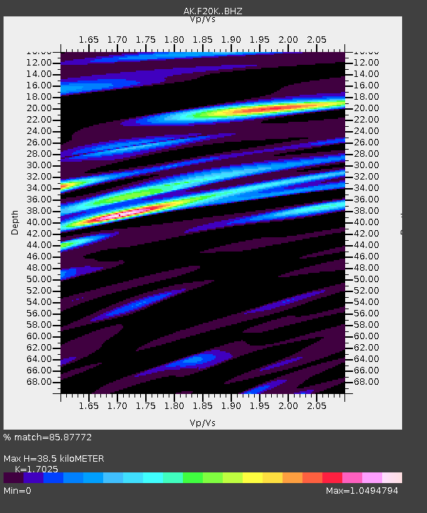
| Estimated Moho Depth: |
38.5 km |
| Estimated Crust Vp/Vs: |
1.70 |
| Assumed Crust Vp: |
6.522 km/s |
| Estimated Crust Vs: |
3.831 km/s |
| Estimated Crust Poisson's Ratio: |
0.24 |
|
| Radial Match: |
85.87772 % |
| Radial Bump: |
400 |
| Transverse Match: |
86.77273 % |
| Transverse Bump: |
400 |
| SOD ConfigId: |
28764291 |
| Insert Time: |
2022-09-19 04:57:00.406 +0000 |
| GWidth: |
2.5 |
| Max Bumps: |
400 |
| Tol: |
0.001 |
|

Signal To Noise
| Channel | StoN | STA | LTA |
| AK:F20K: :BHZ:20220905T05:02:44.659974Z | 16.002934 | 7.797835E-7 | 4.8727532E-8 |
| AK:F20K: :BHN:20220905T05:02:44.659974Z | 1.989485 | 1.2737053E-7 | 6.4021854E-8 |
| AK:F20K: :BHE:20220905T05:02:44.659974Z | 5.4904556 | 3.0495582E-7 | 5.5542895E-8 |
| Arrivals |
| Ps | 4.3 SECOND |
| PpPs | 15 SECOND |
| PsPs/PpSs | 20 SECOND |


