You are here: Home > Network List > TA - USArray Transportable Network (new EarthScope stations) Stations List
> Station TOLK Toolik Lake Research Station, AK, USA > Earthquake Result Viewer
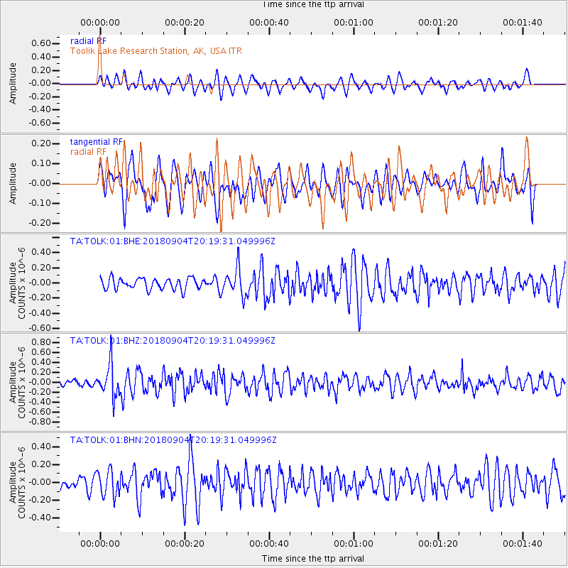
TOLK Toolik Lake Research Station, AK, USA - Earthquake Result Viewer
*The percent match for this event was below the threshold and hence no stack was calculated.
| Earthquake location: |
Near East Coast Of Honshu, Japan |
| Earthquake latitude/longitude: |
36.4/141.5 |
| Earthquake time(UTC): |
2018/09/04 (247) 20:11:19 GMT |
| Earthquake Depth: |
39 km |
| Earthquake Magnitude: |
5.4 Mww |
| Earthquake Catalog/Contributor: |
NEIC PDE/us |
|
| Network: |
TA USArray Transportable Network (new EarthScope stations) |
| Station: |
TOLK Toolik Lake Research Station, AK, USA |
| Lat/Lon: |
68.64 N/149.57 W |
| Elevation: |
760 m |
|
| Distance: |
48.9 deg |
| Az: |
26.949 deg |
| Baz: |
265.929 deg |
| Ray Param: |
$rayparam |
*The percent match for this event was below the threshold and hence was not used in the summary stack. |
|
| Radial Match: |
53.916172 % |
| Radial Bump: |
400 |
| Transverse Match: |
43.5056 % |
| Transverse Bump: |
400 |
| SOD ConfigId: |
2825771 |
| Insert Time: |
2018-09-18 20:37:24.181 +0000 |
| GWidth: |
2.5 |
| Max Bumps: |
400 |
| Tol: |
0.001 |
|
Signal To Noise
| Channel | StoN | STA | LTA |
| TA:TOLK:01:BHZ:20180904T20:19:31.049996Z | 4.0736375 | 3.299564E-7 | 8.099798E-8 |
| TA:TOLK:01:BHN:20180904T20:19:31.049996Z | 1.5874763 | 1.4033076E-7 | 8.839865E-8 |
| TA:TOLK:01:BHE:20180904T20:19:31.049996Z | 2.5427425 | 1.8345848E-7 | 7.2149845E-8 |
| Arrivals |
| Ps | |
| PpPs | |
| PsPs/PpSs | |


