You are here: Home > Network List > AK - Alaska Regional Network Stations List
> Station E27K Coleen River, AK, USA > Earthquake Result Viewer
E27K Coleen River, AK, USA - Earthquake Result Viewer
| Earthquake location: |
Irian Jaya, Indonesia |
| Earthquake latitude/longitude: |
-2.2/138.2 |
| Earthquake time(UTC): |
2022/09/09 (252) 23:31:47 GMT |
| Earthquake Depth: |
18 km |
| Earthquake Magnitude: |
6.2 mww |
| Earthquake Catalog/Contributor: |
NEIC PDE/us |
|
| Network: |
AK Alaska Regional Network |
| Station: |
E27K Coleen River, AK, USA |
| Lat/Lon: |
68.19 N/141.60 W |
| Elevation: |
654 m |
|
| Distance: |
88.4 deg |
| Az: |
21.619 deg |
| Baz: |
260.078 deg |
| Ray Param: |
0.042581737 |
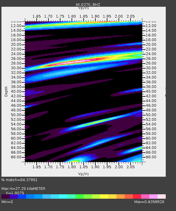
| Estimated Moho Depth: |
27.25 km |
| Estimated Crust Vp/Vs: |
1.81 |
| Assumed Crust Vp: |
6.522 km/s |
| Estimated Crust Vs: |
3.608 km/s |
| Estimated Crust Poisson's Ratio: |
0.28 |
|
| Radial Match: |
84.37951 % |
| Radial Bump: |
388 |
| Transverse Match: |
69.332695 % |
| Transverse Bump: |
400 |
| SOD ConfigId: |
28764291 |
| Insert Time: |
2022-09-23 23:35:08.057 +0000 |
| GWidth: |
2.5 |
| Max Bumps: |
400 |
| Tol: |
0.001 |
|

Signal To Noise
| Channel | StoN | STA | LTA |
| AK:E27K: :BHZ:20220909T23:44:06.799992Z | 6.1850414 | 6.426806E-7 | 1.0390886E-7 |
| AK:E27K: :BHN:20220909T23:44:06.799992Z | 1.0620161 | 1.0134374E-7 | 9.54258E-8 |
| AK:E27K: :BHE:20220909T23:44:06.799992Z | 2.4640942 | 2.1762702E-7 | 8.831928E-8 |
| Arrivals |
| Ps | 3.4 SECOND |
| PpPs | 11 SECOND |
| PsPs/PpSs | 15 SECOND |


