You are here: Home > Network List > AK - Alaska Regional Network Stations List
> Station H23K Yukon River, AK, USA > Earthquake Result Viewer
H23K Yukon River, AK, USA - Earthquake Result Viewer
| Earthquake location: |
Irian Jaya, Indonesia |
| Earthquake latitude/longitude: |
-2.2/138.2 |
| Earthquake time(UTC): |
2022/09/09 (252) 23:31:47 GMT |
| Earthquake Depth: |
18 km |
| Earthquake Magnitude: |
6.2 mww |
| Earthquake Catalog/Contributor: |
NEIC PDE/us |
|
| Network: |
AK Alaska Regional Network |
| Station: |
H23K Yukon River, AK, USA |
| Lat/Lon: |
65.83 N/149.54 W |
| Elevation: |
617 m |
|
| Distance: |
84.8 deg |
| Az: |
23.192 deg |
| Baz: |
252.858 deg |
| Ray Param: |
0.045185868 |
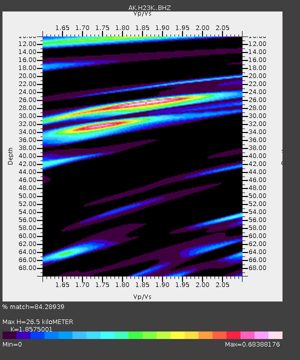
| Estimated Moho Depth: |
26.5 km |
| Estimated Crust Vp/Vs: |
1.86 |
| Assumed Crust Vp: |
6.566 km/s |
| Estimated Crust Vs: |
3.535 km/s |
| Estimated Crust Poisson's Ratio: |
0.30 |
|
| Radial Match: |
84.28939 % |
| Radial Bump: |
379 |
| Transverse Match: |
77.44206 % |
| Transverse Bump: |
400 |
| SOD ConfigId: |
28764291 |
| Insert Time: |
2022-09-23 23:35:56.564 +0000 |
| GWidth: |
2.5 |
| Max Bumps: |
400 |
| Tol: |
0.001 |
|

Signal To Noise
| Channel | StoN | STA | LTA |
| AK:H23K: :BHZ:20220909T23:43:49.320012Z | 7.9769816 | 7.9837866E-7 | 1.0008531E-7 |
| AK:H23K: :BHN:20220909T23:43:49.320012Z | 2.1169662 | 1.9128395E-7 | 9.0357574E-8 |
| AK:H23K: :BHE:20220909T23:43:49.320012Z | 2.997907 | 2.7001593E-7 | 9.0068156E-8 |
| Arrivals |
| Ps | 3.5 SECOND |
| PpPs | 11 SECOND |
| PsPs/PpSs | 15 SECOND |


