You are here: Home > Network List > MM - Myanmar National Seismic Network Stations List
> Station TGI Taung Gyi, Myanmar > Earthquake Result Viewer
TGI Taung Gyi, Myanmar - Earthquake Result Viewer
| Earthquake location: |
Irian Jaya, Indonesia |
| Earthquake latitude/longitude: |
-2.2/138.2 |
| Earthquake time(UTC): |
2022/09/10 (253) 00:05:12 GMT |
| Earthquake Depth: |
16 km |
| Earthquake Magnitude: |
6.2 mww |
| Earthquake Catalog/Contributor: |
NEIC PDE/us |
|
| Network: |
MM Myanmar National Seismic Network |
| Station: |
TGI Taung Gyi, Myanmar |
| Lat/Lon: |
20.77 N/97.03 E |
| Elevation: |
1458 m |
|
| Distance: |
46.3 deg |
| Az: |
301.63 deg |
| Baz: |
114.607 deg |
| Ray Param: |
0.07070717 |
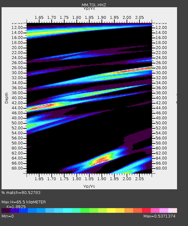
| Estimated Moho Depth: |
65.5 km |
| Estimated Crust Vp/Vs: |
1.89 |
| Assumed Crust Vp: |
6.316 km/s |
| Estimated Crust Vs: |
3.337 km/s |
| Estimated Crust Poisson's Ratio: |
0.31 |
|
| Radial Match: |
90.52783 % |
| Radial Bump: |
387 |
| Transverse Match: |
59.223114 % |
| Transverse Bump: |
400 |
| SOD ConfigId: |
28764291 |
| Insert Time: |
2022-09-24 00:18:54.526 +0000 |
| GWidth: |
2.5 |
| Max Bumps: |
400 |
| Tol: |
0.001 |
|

Signal To Noise
| Channel | StoN | STA | LTA |
| MM:TGI: :HHZ:20220910T00:13:06.419992Z | 3.544315 | 1.028497E-6 | 2.9018213E-7 |
| MM:TGI: :HHN:20220910T00:13:06.419992Z | 0.7335104 | 3.012787E-7 | 4.1073542E-7 |
| MM:TGI: :HHE:20220910T00:13:06.419992Z | 1.635082 | 6.938946E-7 | 4.243791E-7 |
| Arrivals |
| Ps | 9.8 SECOND |
| PpPs | 28 SECOND |
| PsPs/PpSs | 38 SECOND |


