You are here: Home > Network List > US - United States National Seismic Network Stations List
> Station WUAZ Wupatki, Arizona, USA > Earthquake Result Viewer
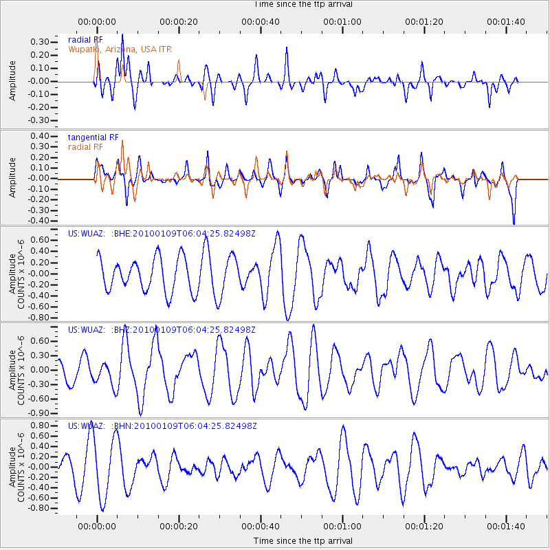
WUAZ Wupatki, Arizona, USA - Earthquake Result Viewer
*The percent match for this event was below the threshold and hence no stack was calculated.
| Earthquake location: |
Solomon Islands |
| Earthquake latitude/longitude: |
-9.1/157.6 |
| Earthquake time(UTC): |
2010/01/09 (009) 05:51:30 GMT |
| Earthquake Depth: |
12 km |
| Earthquake Magnitude: |
6.0 MB, 6.2 MS, 6.2 MW, 6.2 MW |
| Earthquake Catalog/Contributor: |
WHDF/NEIC |
|
| Network: |
US United States National Seismic Network |
| Station: |
WUAZ Wupatki, Arizona, USA |
| Lat/Lon: |
35.52 N/111.37 W |
| Elevation: |
1592 m |
|
| Distance: |
96.0 deg |
| Az: |
55.106 deg |
| Baz: |
263.148 deg |
| Ray Param: |
$rayparam |
*The percent match for this event was below the threshold and hence was not used in the summary stack. |
|
| Radial Match: |
58.181488 % |
| Radial Bump: |
400 |
| Transverse Match: |
58.21913 % |
| Transverse Bump: |
400 |
| SOD ConfigId: |
1 |
| Insert Time: |
2010-03-17 21:01:50.096 +0000 |
| GWidth: |
2.5 |
| Max Bumps: |
400 |
| Tol: |
0.001 |
|
Signal To Noise
| Channel | StoN | STA | LTA |
| US:WUAZ: :BHZ:20100109T06:04:25.82498Z | 1.5481104 | 2.4621332E-7 | 1.5904119E-7 |
| US:WUAZ: :BHN:20100109T06:04:25.82498Z | 1.4270557 | 5.8031196E-7 | 4.0664983E-7 |
| US:WUAZ: :BHE:20100109T06:04:25.82498Z | 1.2659562 | 3.6986557E-7 | 2.92163E-7 |
| Arrivals |
| Ps | |
| PpPs | |
| PsPs/PpSs | |


