You are here: Home > Network List > AU - Australian Seismological Centre Stations List
> Station KLGHH Kalgoorlie Hampton Hill, WA ,GSWA network > Earthquake Result Viewer
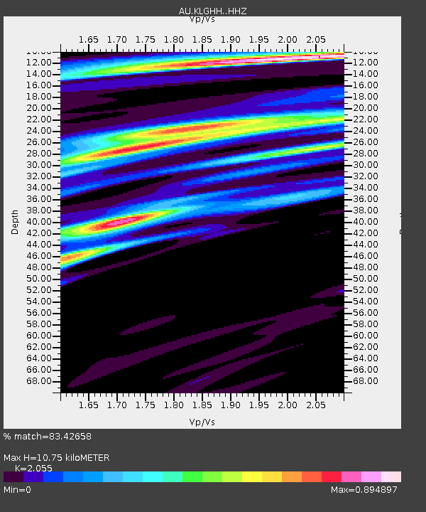
KLGHH Kalgoorlie Hampton Hill, WA ,GSWA network - Earthquake Result Viewer
| Earthquake location: |
Southern Sumatra, Indonesia |
| Earthquake latitude/longitude: |
-1.1/98.6 |
| Earthquake time(UTC): |
2022/09/10 (253) 23:10:44 GMT |
| Earthquake Depth: |
20 km |
| Earthquake Magnitude: |
6.0 Mww |
| Earthquake Catalog/Contributor: |
NEIC PDE/us |
|
| Network: |
AU Australian Seismological Centre |
| Station: |
KLGHH Kalgoorlie Hampton Hill, WA ,GSWA network |
| Lat/Lon: |
30.75 S/121.75 E |
| Elevation: |
386 m |
|
| Distance: |
36.7 deg |
| Az: |
145.565 deg |
| Baz: |
318.951 deg |
| Ray Param: |
0.07652684 |
| Estimated Moho Depth: |
10.75 km |
| Estimated Crust Vp/Vs: |
2.06 |
| Assumed Crust Vp: |
6.459 km/s |
| Estimated Crust Vs: |
3.143 km/s |
| Estimated Crust Poisson's Ratio: |
0.34 |
|
| Radial Match: |
83.42658 % |
| Radial Bump: |
382 |
| Transverse Match: |
73.919464 % |
| Transverse Bump: |
400 |
| SOD ConfigId: |
28764291 |
| Insert Time: |
2022-09-24 23:16:43.306 +0000 |
| GWidth: |
2.5 |
| Max Bumps: |
400 |
| Tol: |
0.001 |
|

Signal To Noise
| Channel | StoN | STA | LTA |
| AU:KLGHH: :HHZ:20220910T23:17:19.465005Z | 0.8452491 | 8.7871786E-7 | 1.0395962E-6 |
| AU:KLGHH: :HHN:20220910T23:17:19.465005Z | 1.2749115 | 9.2860347E-7 | 7.28367E-7 |
| AU:KLGHH: :HHE:20220910T23:17:19.465005Z | 0.9353329 | 4.2663723E-7 | 4.561341E-7 |
| Arrivals |
| Ps | 1.9 SECOND |
| PpPs | 4.8 SECOND |
| PsPs/PpSs | 6.6 SECOND |


