You are here: Home > Network List > CN - Canadian National Seismograph Network Stations List
> Station ULM LAC DU BONNET, MB, CANADA > Earthquake Result Viewer
ULM LAC DU BONNET, MB, CANADA - Earthquake Result Viewer
| Earthquake location: |
Haiti Region |
| Earthquake latitude/longitude: |
18.4/-72.6 |
| Earthquake time(UTC): |
2010/01/12 (012) 21:53:10 GMT |
| Earthquake Depth: |
13 km |
| Earthquake Magnitude: |
6.8 MB, 7.3 MS, 7.0 MW, 7.0 MW |
| Earthquake Catalog/Contributor: |
WHDF/NEIC |
|
| Network: |
CN Canadian National Seismograph Network |
| Station: |
ULM LAC DU BONNET, MB, CANADA |
| Lat/Lon: |
50.25 N/95.87 W |
| Elevation: |
251 m |
|
| Distance: |
36.8 deg |
| Az: |
334.911 deg |
| Baz: |
141.17 deg |
| Ray Param: |
0.07647924 |
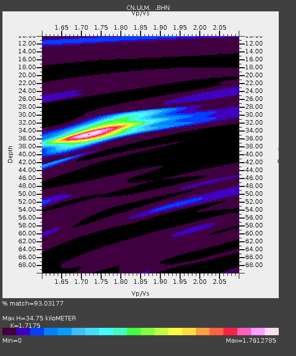
| Estimated Moho Depth: |
34.75 km |
| Estimated Crust Vp/Vs: |
1.72 |
| Assumed Crust Vp: |
6.459 km/s |
| Estimated Crust Vs: |
3.761 km/s |
| Estimated Crust Poisson's Ratio: |
0.24 |
|
| Radial Match: |
93.03177 % |
| Radial Bump: |
211 |
| Transverse Match: |
70.27259 % |
| Transverse Bump: |
400 |
| SOD ConfigId: |
1 |
| Insert Time: |
2010-03-17 21:05:57.915 +0000 |
| GWidth: |
2.5 |
| Max Bumps: |
400 |
| Tol: |
0.001 |
|
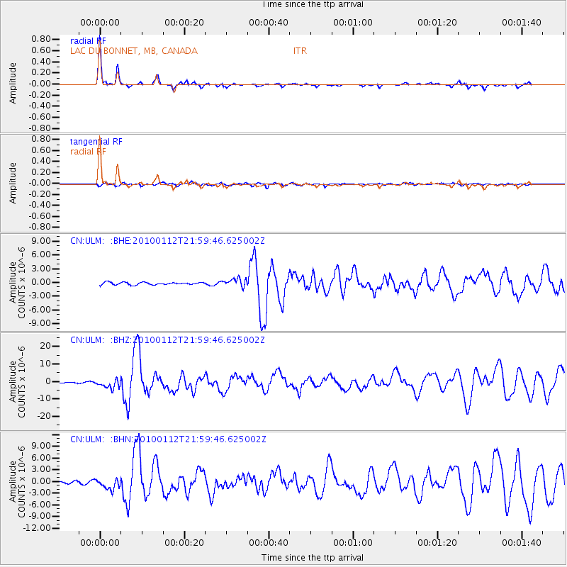
Signal To Noise
| Channel | StoN | STA | LTA |
| CN:ULM: :BHZ:20100112T21:59:46.625002Z | 6.1295404 | 2.4972876E-6 | 4.074184E-7 |
| CN:ULM: :BHN:20100112T21:59:46.625002Z | 3.4511087 | 1.3918011E-6 | 4.03291E-7 |
| CN:ULM: :BHE:20100112T21:59:46.625002Z | 3.36783 | 8.712595E-7 | 2.5870057E-7 |
| Arrivals |
| Ps | 4.2 SECOND |
| PpPs | 14 SECOND |
| PsPs/PpSs | 18 SECOND |


