You are here: Home > Network List > IU - Global Seismograph Network (GSN - IRIS/USGS) Stations List
> Station MACI Morro de la Arena, Canary Islands > Earthquake Result Viewer
MACI Morro de la Arena, Canary Islands - Earthquake Result Viewer
| Earthquake location: |
Haiti Region |
| Earthquake latitude/longitude: |
18.4/-72.6 |
| Earthquake time(UTC): |
2010/01/12 (012) 21:53:10 GMT |
| Earthquake Depth: |
13 km |
| Earthquake Magnitude: |
6.8 MB, 7.3 MS, 7.0 MW, 7.0 MW |
| Earthquake Catalog/Contributor: |
WHDF/NEIC |
|
| Network: |
IU Global Seismograph Network (GSN - IRIS/USGS) |
| Station: |
MACI Morro de la Arena, Canary Islands |
| Lat/Lon: |
28.25 N/16.51 W |
| Elevation: |
1674 m |
|
| Distance: |
52.0 deg |
| Az: |
68.244 deg |
| Baz: |
272.027 deg |
| Ray Param: |
0.06703241 |
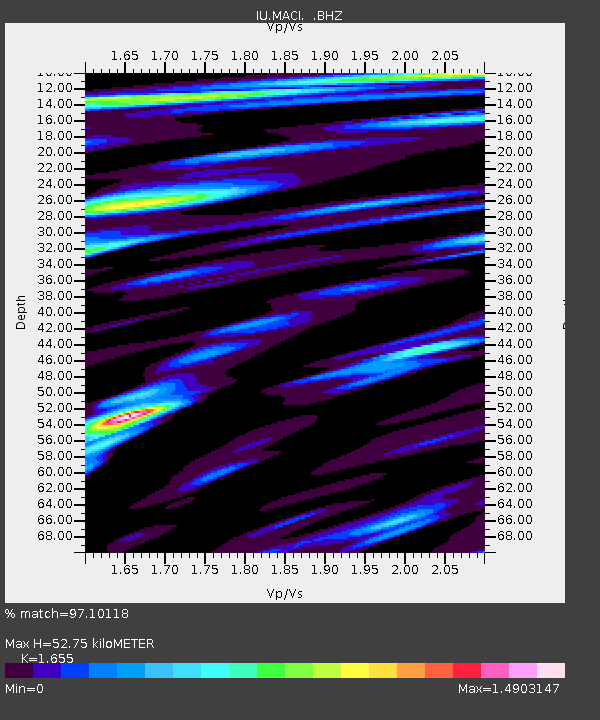
| Estimated Moho Depth: |
52.75 km |
| Estimated Crust Vp/Vs: |
1.65 |
| Assumed Crust Vp: |
4.662 km/s |
| Estimated Crust Vs: |
2.817 km/s |
| Estimated Crust Poisson's Ratio: |
0.21 |
|
| Radial Match: |
97.10118 % |
| Radial Bump: |
352 |
| Transverse Match: |
94.70957 % |
| Transverse Bump: |
400 |
| SOD ConfigId: |
1 |
| Insert Time: |
2010-03-17 21:07:09.557 +0000 |
| GWidth: |
2.5 |
| Max Bumps: |
400 |
| Tol: |
0.001 |
|

Signal To Noise
| Channel | StoN | STA | LTA |
| IU:MACI: :BHZ:20100112T22:01:48.04999Z | 4.8710175 | 1.2548622E-6 | 2.576181E-7 |
| IU:MACI: :BHN:20100112T22:01:48.04999Z | 2.089933 | 3.6588878E-7 | 1.7507202E-7 |
| IU:MACI: :BHE:20100112T22:01:48.04999Z | 3.3454313 | 5.998118E-7 | 1.7929281E-7 |
| Arrivals |
| Ps | 7.6 SECOND |
| PpPs | 29 SECOND |
| PsPs/PpSs | 37 SECOND |


