You are here: Home > Network List > AK - Alaska Regional Network Stations List
> Station BAE Barry Arm East, AK, USA > Earthquake Result Viewer
BAE Barry Arm East, AK, USA - Earthquake Result Viewer
| Earthquake location: |
Eastern New Guinea Reg., P.N.G. |
| Earthquake latitude/longitude: |
-6.2/146.5 |
| Earthquake time(UTC): |
2022/09/10 (253) 23:46:55 GMT |
| Earthquake Depth: |
61 km |
| Earthquake Magnitude: |
7.6 mww |
| Earthquake Catalog/Contributor: |
NEIC PDE/us |
|
| Network: |
AK Alaska Regional Network |
| Station: |
BAE Barry Arm East, AK, USA |
| Lat/Lon: |
61.13 N/148.12 W |
| Elevation: |
578 m |
|
| Distance: |
83.9 deg |
| Az: |
26.346 deg |
| Baz: |
245.391 deg |
| Ray Param: |
0.045761544 |
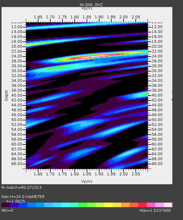
| Estimated Moho Depth: |
24.0 km |
| Estimated Crust Vp/Vs: |
1.86 |
| Assumed Crust Vp: |
6.566 km/s |
| Estimated Crust Vs: |
3.525 km/s |
| Estimated Crust Poisson's Ratio: |
0.30 |
|
| Radial Match: |
90.071014 % |
| Radial Bump: |
400 |
| Transverse Match: |
80.090225 % |
| Transverse Bump: |
400 |
| SOD ConfigId: |
28764291 |
| Insert Time: |
2022-09-24 23:48:46.927 +0000 |
| GWidth: |
2.5 |
| Max Bumps: |
400 |
| Tol: |
0.001 |
|

Signal To Noise
| Channel | StoN | STA | LTA |
| AK:BAE: :BHZ:20220910T23:58:47.087979Z | 26.31881 | 7.809414E-6 | 2.9672364E-7 |
| AK:BAE: :BHN:20220910T23:58:47.087979Z | 7.9729195 | 1.9859795E-6 | 2.4909062E-7 |
| AK:BAE: :BHE:20220910T23:58:47.087979Z | 11.40269 | 2.7959854E-6 | 2.4520403E-7 |
| Arrivals |
| Ps | 3.2 SECOND |
| PpPs | 10 SECOND |
| PsPs/PpSs | 13 SECOND |


