You are here: Home > Network List > XA95 - Missouri to Massachusetts Transect Stations List
> Station MM01 North Hampton, Massachusetts > Earthquake Result Viewer
MM01 North Hampton, Massachusetts - Earthquake Result Viewer
| Earthquake location: |
Near Coast Of Northern Chile |
| Earthquake latitude/longitude: |
-23.2/-70.6 |
| Earthquake time(UTC): |
1995/08/02 (214) 00:14:09 GMT |
| Earthquake Depth: |
33 km |
| Earthquake Magnitude: |
5.4 MB, 5.5 MS, 5.3 UNKNOWN |
| Earthquake Catalog/Contributor: |
WHDF/NEIC |
|
| Network: |
XA Missouri to Massachusetts Transect |
| Station: |
MM01 North Hampton, Massachusetts |
| Lat/Lon: |
42.32 N/72.71 W |
| Elevation: |
122 m |
|
| Distance: |
65.2 deg |
| Az: |
358.256 deg |
| Baz: |
177.836 deg |
| Ray Param: |
0.058395345 |
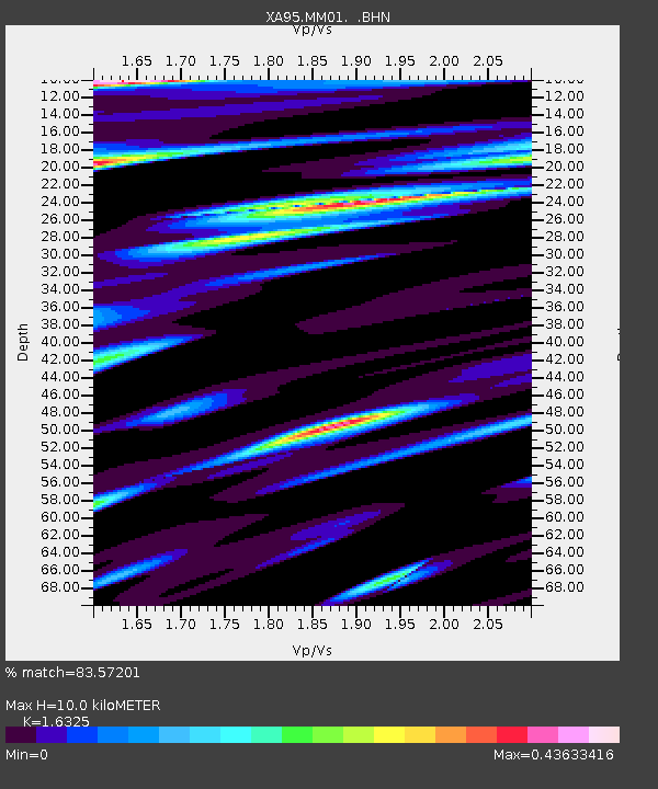
| Estimated Moho Depth: |
10.0 km |
| Estimated Crust Vp/Vs: |
1.63 |
| Assumed Crust Vp: |
6.419 km/s |
| Estimated Crust Vs: |
3.932 km/s |
| Estimated Crust Poisson's Ratio: |
0.20 |
|
| Radial Match: |
83.57201 % |
| Radial Bump: |
287 |
| Transverse Match: |
51.87151 % |
| Transverse Bump: |
400 |
| SOD ConfigId: |
29242 |
| Insert Time: |
2010-02-26 17:42:16.984 +0000 |
| GWidth: |
2.5 |
| Max Bumps: |
400 |
| Tol: |
0.001 |
|
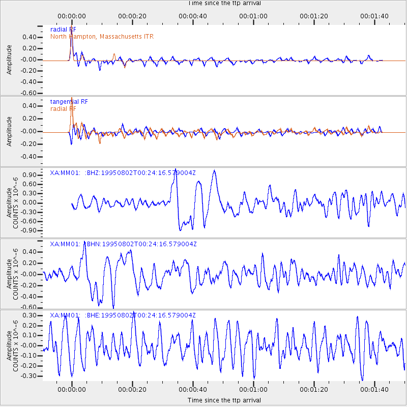
Signal To Noise
| Channel | StoN | STA | LTA |
| XA:MM01: :BHN:19950802T00:24:16.579004Z | 3.1497152 | 2.5249417E-7 | 8.0164135E-8 |
| XA:MM01: :BHE:19950802T00:24:16.579004Z | 1.9327866 | 1.8714778E-7 | 9.682796E-8 |
| XA:MM01: :BHZ:19950802T00:24:16.579004Z | 3.9113095 | 4.8114106E-7 | 1.2301278E-7 |
| Arrivals |
| Ps | 1.0 SECOND |
| PpPs | 3.9 SECOND |
| PsPs/PpSs | 5.0 SECOND |


