You are here: Home > Network List > XA95 - Missouri to Massachusetts Transect Stations List
> Station MM01 North Hampton, Massachusetts > Earthquake Result Viewer
MM01 North Hampton, Massachusetts - Earthquake Result Viewer
| Earthquake location: |
Chiapas, Mexico |
| Earthquake latitude/longitude: |
16.9/-93.5 |
| Earthquake time(UTC): |
1995/10/21 (294) 02:38:57 GMT |
| Earthquake Depth: |
161 km |
| Earthquake Magnitude: |
6.2 MB, 7.3 UNKNOWN, 7.3 MW |
| Earthquake Catalog/Contributor: |
WHDF/NEIC |
|
| Network: |
XA Missouri to Massachusetts Transect |
| Station: |
MM01 North Hampton, Massachusetts |
| Lat/Lon: |
42.32 N/72.71 W |
| Elevation: |
122 m |
|
| Distance: |
30.9 deg |
| Az: |
30.724 deg |
| Baz: |
221.263 deg |
| Ray Param: |
0.078822635 |
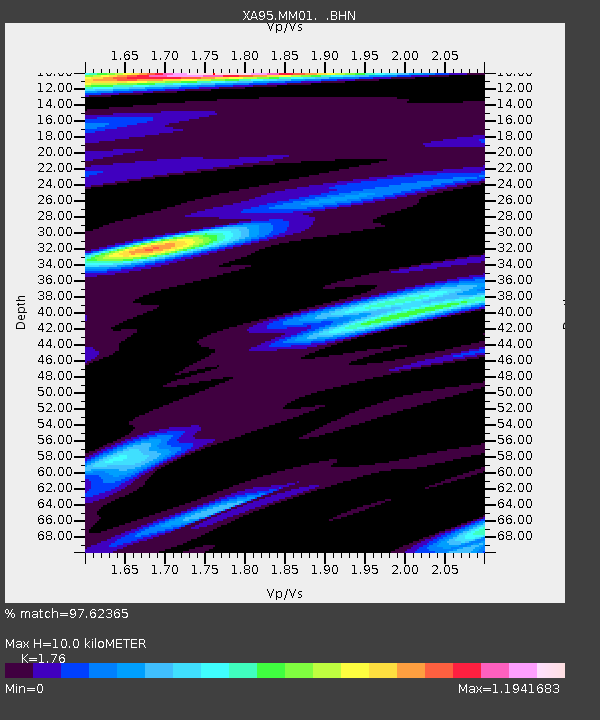
| Estimated Moho Depth: |
10.0 km |
| Estimated Crust Vp/Vs: |
1.76 |
| Assumed Crust Vp: |
6.419 km/s |
| Estimated Crust Vs: |
3.647 km/s |
| Estimated Crust Poisson's Ratio: |
0.26 |
|
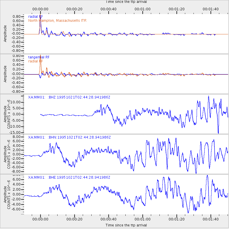
| Radial Match: |
97.62365 % |
| Radial Bump: |
229 |
| Transverse Match: |
90.055305 % |
| Transverse Bump: |
400 |
| SOD ConfigId: |
6273 |
| Insert Time: |
2010-02-26 17:42:18.293 +0000 |
| GWidth: |
2.5 |
| Max Bumps: |
400 |
| Tol: |
0.001 |
|
Signal To Noise
| Channel | StoN | STA | LTA |
| XA:MM01: :BHN:19951021T02:44:28.941986Z | 4.604027 | 1.1603573E-6 | 2.52031E-7 |
| XA:MM01: :BHE:19951021T02:44:28.941986Z | 3.8709977 | 8.1192076E-7 | 2.0974457E-7 |
| XA:MM01: :BHZ:19951021T02:44:28.941986Z | 6.9422426 | 2.2732258E-6 | 3.2744833E-7 |
| Arrivals |
| Ps | 1.3 SECOND |
| PpPs | 4.0 SECOND |
| PsPs/PpSs | 5.3 SECOND |


