You are here: Home > Network List > US - United States National Seismic Network Stations List
> Station EYMN Ely, Minnesota, USA > Earthquake Result Viewer
EYMN Ely, Minnesota, USA - Earthquake Result Viewer
| Earthquake location: |
Haiti Region |
| Earthquake latitude/longitude: |
18.4/-72.6 |
| Earthquake time(UTC): |
2010/01/12 (012) 21:53:10 GMT |
| Earthquake Depth: |
13 km |
| Earthquake Magnitude: |
6.8 MB, 7.3 MS, 7.0 MW, 7.0 MW |
| Earthquake Catalog/Contributor: |
WHDF/NEIC |
|
| Network: |
US United States National Seismic Network |
| Station: |
EYMN Ely, Minnesota, USA |
| Lat/Lon: |
47.95 N/91.50 W |
| Elevation: |
475 m |
|
| Distance: |
33.2 deg |
| Az: |
336.554 deg |
| Baz: |
145.819 deg |
| Ray Param: |
0.07829748 |
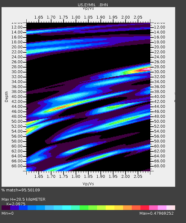
| Estimated Moho Depth: |
28.5 km |
| Estimated Crust Vp/Vs: |
2.10 |
| Assumed Crust Vp: |
6.467 km/s |
| Estimated Crust Vs: |
3.083 km/s |
| Estimated Crust Poisson's Ratio: |
0.35 |
|
| Radial Match: |
95.58189 % |
| Radial Bump: |
213 |
| Transverse Match: |
71.97587 % |
| Transverse Bump: |
400 |
| SOD ConfigId: |
1 |
| Insert Time: |
2010-03-17 21:11:31.049 +0000 |
| GWidth: |
2.5 |
| Max Bumps: |
400 |
| Tol: |
0.001 |
|

Signal To Noise
| Channel | StoN | STA | LTA |
| US:EYMN: :BHZ:20100112T21:59:15.975009Z | 3.144394 | 4.2848887E-6 | 1.3627074E-6 |
| US:EYMN: :BHN:20100112T21:59:15.975009Z | 3.6163905 | 2.6938462E-6 | 7.448992E-7 |
| US:EYMN: :BHE:20100112T21:59:15.975009Z | 2.206323 | 2.093707E-6 | 9.489576E-7 |
| Arrivals |
| Ps | 5.2 SECOND |
| PpPs | 13 SECOND |
| PsPs/PpSs | 18 SECOND |


