You are here: Home > Network List > AV - Alaska Volcano Observatory Stations List
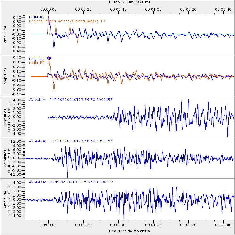
> Station AMKA Regional Station, Amchitka Island, Alaska > Earthquake Result Viewer
AMKA Regional Station, Amchitka Island, Alaska - Earthquake Result Viewer
| Earthquake location: |
Eastern New Guinea Reg., P.N.G. |
| Earthquake latitude/longitude: |
-6.2/146.5 |
| Earthquake time(UTC): |
2022/09/10 (253) 23:46:55 GMT |
| Earthquake Depth: |
61 km |
| Earthquake Magnitude: |
7.6 mww |
| Earthquake Catalog/Contributor: |
NEIC PDE/us |
|
| Network: |
AV Alaska Volcano Observatory |
| Station: |
AMKA Regional Station, Amchitka Island, Alaska |
| Lat/Lon: |
51.38 N/179.30 E |
| Elevation: |
116 m |
|
| Distance: |
63.9 deg |
| Az: |
22.229 deg |
| Baz: |
216.878 deg |
| Ray Param: |
0.05911855 |
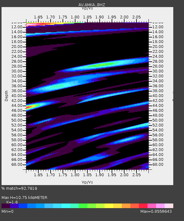
| Estimated Moho Depth: |
10.75 km |
| Estimated Crust Vp/Vs: |
1.60 |
| Assumed Crust Vp: |
6.183 km/s |
| Estimated Crust Vs: |
3.864 km/s |
| Estimated Crust Poisson's Ratio: |
0.18 |
|
| Radial Match: |
92.7616 % |
| Radial Bump: |
400 |
| Transverse Match: |
90.18634 % |
| Transverse Bump: |
400 |
| SOD ConfigId: |
28764291 |
| Insert Time: |
2022-09-24 23:54:27.228 +0000 |
| GWidth: |
2.5 |
| Max Bumps: |
400 |
| Tol: |
0.001 |
|
Signal To Noise
| Channel | StoN | STA | LTA |
| AV:AMKA: :BHZ:20220910T23:56:50.899015Z | 5.60051 | 1.0311638E-6 | 1.8411961E-7 |
| AV:AMKA: :BHN:20220910T23:56:50.899015Z | 1.7121624 | 2.728314E-7 | 1.5934901E-7 |
| AV:AMKA: :BHE:20220910T23:56:50.899015Z | 1.383389 | 2.3373364E-7 | 1.6895729E-7 |
| Arrivals |
| Ps | 1.1 SECOND |
| PpPs | 4.3 SECOND |
| PsPs/PpSs | 5.4 SECOND |


