You are here: Home > Network List > US - United States National Seismic Network Stations List
> Station LAO LASA Array, Montana, USA > Earthquake Result Viewer
LAO LASA Array, Montana, USA - Earthquake Result Viewer
| Earthquake location: |
Haiti Region |
| Earthquake latitude/longitude: |
18.4/-72.6 |
| Earthquake time(UTC): |
2010/01/12 (012) 21:53:10 GMT |
| Earthquake Depth: |
13 km |
| Earthquake Magnitude: |
6.8 MB, 7.3 MS, 7.0 MW, 7.0 MW |
| Earthquake Catalog/Contributor: |
WHDF/NEIC |
|
| Network: |
US United States National Seismic Network |
| Station: |
LAO LASA Array, Montana, USA |
| Lat/Lon: |
46.69 N/106.22 W |
| Elevation: |
902 m |
|
| Distance: |
39.5 deg |
| Az: |
323.114 deg |
| Baz: |
124.139 deg |
| Ray Param: |
0.07496308 |
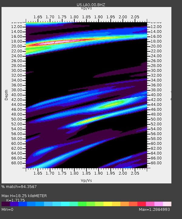
| Estimated Moho Depth: |
18.25 km |
| Estimated Crust Vp/Vs: |
1.72 |
| Assumed Crust Vp: |
6.438 km/s |
| Estimated Crust Vs: |
3.748 km/s |
| Estimated Crust Poisson's Ratio: |
0.24 |
|
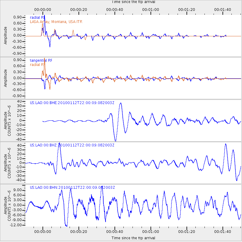
| Radial Match: |
94.3567 % |
| Radial Bump: |
208 |
| Transverse Match: |
81.56993 % |
| Transverse Bump: |
248 |
| SOD ConfigId: |
1 |
| Insert Time: |
2010-03-17 21:12:02.248 +0000 |
| GWidth: |
2.5 |
| Max Bumps: |
400 |
| Tol: |
0.001 |
|
Signal To Noise
| Channel | StoN | STA | LTA |
| US:LAO:00:BHZ:20100112T22:00:09.082003Z | 2.4192495 | 1.7845223E-6 | 7.376347E-7 |
| US:LAO:00:BHN:20100112T22:00:09.082003Z | 0.47588786 | 1.7633736E-6 | 3.7054392E-6 |
| US:LAO:00:BHE:20100112T22:00:09.082003Z | 1.2193233 | 1.3229327E-6 | 1.0849728E-6 |
| Arrivals |
| Ps | 2.2 SECOND |
| PpPs | 7.2 SECOND |
| PsPs/PpSs | 9.3 SECOND |


